


|
||

|

|
|

|
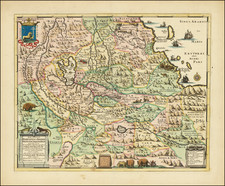
Decorative example of this finely engraved map of the Congo, Gabon and Angola originally created by Nicholas Sanson, the Royal Geographer to the King of France in 1657. This map accurately showcased the major geographical features such as rivers, mountains, and settlements of the region during that period.
In the regions depicted, several tribes held prominence. Among them were the Kongo, Loango, Ovimbundu, Bakongo, Mbundu, and Fang. These tribes had established systems of governance and trade networks which affected their interactions with foreign traders and settlers.
The latter half of the 17th century observed a significant increase in trade, especially with European powers taking keen interest in the African coast. The Portuguese were the early European settlers, particularly in Angola. Their motives extended from converting locals to Christianity to controlling the burgeoning trade routes. As the century progressed, other European nations, including the Dutch, British, and French, began to establish their presence.
Tragically, this period also marked the escalation of the Atlantic Slave Trade. European powers began the mass transportation of Africans to the New World, with the regions highlighted in Sanson's map serving as primary centers for this activity. Specifically, the coastal kingdom of Loango emerged as a major trading hub for slaves, ivory, and copper. Similarly, the Kongo kingdom, initially a potent entity in its own right, became heavily involved in European trade, supplying a significant number of slaves to the Portuguese.
Beyond the slave trade, European traders sought after other goods, such as ivory, gold, copper, and textiles. The rivers, especially the Congo River, played an essential role in these commercial activities, acting as significant navigational and trade routes.
Nicholas Sanson (1600-1667) is considered the father of French cartography in its golden age from the mid-seventeenth century to the mid-eighteenth. Over the course of his career he produced over 300 maps; they are known for their clean style and extensive research. Sanson was largely responsible for beginning the shift of cartographic production and excellence from Amsterdam to Paris in the later-seventeenth century.
Sanson was born in Abbeville in Picardy. He made his first map at age twenty, a wall map of ancient Gaul. Upon moving to Paris, he gained the attention of Cardinal Richelieu, who made an introduction of Sanson to King Louis XIII. This led to Sanson's tutoring of the king and the granting of the title ingenieur-geographe du roi.
His success can be chalked up to his geographic and research skills, but also to his partnership with Pierre Mariette. Early in his career, Sanson worked primarily with the publisher Melchior Tavernier. Mariette purchased Tavernier’s business in 1644. Sanson worked with Mariette until 1657, when the latter died. Mariette’s son, also Pierre, helped to publish the Cartes générales de toutes les parties du monde (1658), Sanson' atlas and the first French world atlas.
![Carte Routiere de Madagascar et dependances [set of 4 folding maps]](https://storage.googleapis.com/raremaps/img/small/89247.jpg)

![(Horn of Africa) Abessinien Somaliländern [cover title:] Neue Karte von Abessinien und Somaliländern](https://storage.googleapis.com/raremaps/img/small/97482.jpg)