|
||

|

|
|

|
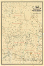
An Important Early Wall Map of British Columbia
Nice example of Frederic Newton Gisborne's monumental map of the Province of British Columbia and the Straits of Juan de Fuca, one of the earliest large format maps of the Province.
The present map is the first large format map of British Columbia to make a detailed survey of the Telegraph and Cable lines in the region, including Canadian Governmental lines, Canadian Pacific Rail Road lines, American owned lines and newly proposed lines, resulting from the recent visit by Frederic Newton Gisborne. The lines include the CPRR's lines in Washington Territory on the south and eastern side of the straits of Juan de Fuca and the line from New Dungeness, Washington to Victoria, BC.
While prepared to illustrate the cable lines in the region, the map is also an exceptional topographical overview, illustrating the locations of the most important watersheds, Indian Villages, Forts and other details in the more remote regions of the Province.
The map is also one of the earliest large format separately published maps of British Columbia, having been issued one year before Edward Mohun's map Province of British Columbia produced by the Department of Lands and Works, which would become the standard map for British Columbia for a decade. Prior map's such as Trutch's maps, did not extend nearly as far north in the province.
Gisborne was a British polymath who arrived in Canada in the late 1840s and became one of its pre-eminent figures in Telegraphy. His career spanned over 40 years, during which time he played roles in a number of the most important projects in Canada. In 1879, he was hired as Canada's first Superintendent of the Dominion's telegraph and signal service.
By 1882, he had travelled to British Columbia and personally supervised the reorganization and restructuring of British Columbia's nascent telegraph system.
The inset map of the World locates the principal telegraph lines and electric cable connection around the world.
Frederic Gisborne was a farmer, telegraph agent, civil servant, engineer, and inventor.
Gisborne spent his entire life advancing pioneering projects in the telegraph and transatlantic cable industries, along with several interludes where he spent time running larger mining concerns.
In 1879, the Dominion of Canada appointed him the first superintendent of the dominion telegraph and signal service. He spent the next decade restructuring and improving Canada's domestic and transoceanic cable interests.