This item has been sold, but you can enter your email address to be notified if another example becomes available.


|
||

|

|
|

|
Stock# 8021
Description
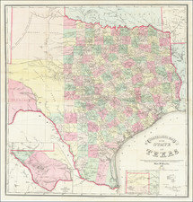
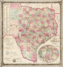
Nice map of Texas and parts of New Mexico and Indian Territory. The map is especially useful for tracking the evolution of the counties in Texas and New Mexico and includes several ephemeral names and borders, most notably the stub of Bernalillo County, which had previously criss-crossed the state but which was by this date located solely on the western side of the state, not withstanding its appearance here on the right. Shows roads, railroads, towns, forts and some Indian information. Adam & Charles Black were among the leading publishers of atlases and travel books in the 19th Century England.
![(Texas - Apache Depredations in Mexico) Discurso Que Pronunció el señor Coronel D. José Joaquin Calvo, Comandante general del Estado de Chihuahua, al entrar en ejercicio del Supremo Poder Ejecutivo del mismo [caption title]](https://storage.googleapis.com/raremaps/img/small/93111.jpg)