


|
||

|

|
|

|
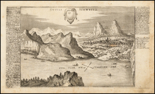
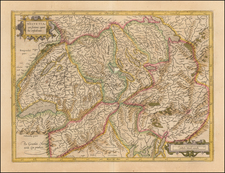
Scarce map of the St. Gothard Mountain range of Central Switzerland, by Charles-François Exchaquet.
Detailed map of a portion of the Central Alps including the St. Gothard and Forks Mountains, the sources of the Rhine, the Rhine, the Ticino and the Reuss, the Urseren Valley, the Levantine Valley and all the surrounding mountains
Charles-François Exchaquet (1746-1792) was a Swiss engineer, cartographer and mountaineer. In 1781 he became director of the smelting works of Servoz, responsible for the mineral and metallurgical operations. In 1787, he was the first tourist to cross the Col du Géant, the mountain saddle between the Tour Ronde and the Dent du Géant, from Chamonix in the Arve Valley to Courmayeur in Val d'Aosta. In the same year, he created and sold relief maps of the Mont-Blanc Massif and the Saint-Gotthard Massif.
![Atlas Novus Reipublicae Helveticae XX. Mappis . . . [with] Schweitzer-Geographie. Samt den Merkwurdigkeiten in den Alpen und hohen Bergen. Zur Erläuterung der hommannischen Charten herausgegeben](https://storage.googleapis.com/raremaps/img/small/84155.jpg)