|
||

|

|
|

|
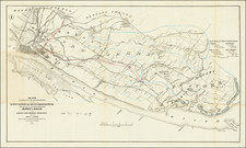
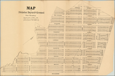
Previously Unknown First Edition of the Longworth Map of New York City. A Possible Working Draft for the Second Edition, with Manuscript Corrections.
Rare early street map of Lower Manhattan below 14th Street, showing the city's early-19th-century layout in exacting detail.
The map is one of the rarer plans of early New York, notable for its extensive street-by-street depiction of the city. The map shows both the built environment of the southern tip of the island as well as the proposed street structure slightly higher up the island, where farmland was still giving way to urbanization. The map includes keys to churches, public buildings, streets, and street and neighborhood name changes. Of note is that the map also shows streams that were, very soon after the map's publication, buried underground or otherwise modified.
The present example of the map evidently carries significant annotations. While there are several possible explanations for these annotations, the most likely is that this is a publisher's proof example of the map, used to double-check its accuracy. The map includes revisions to the proposed price of City Hall and annotations that appear to ascribe certain neighborhoods to certain people. The most likely explanation for these annotations is that this example of the map was used to verify neighborhoods and streets before the issuance of the second edition of the map.
The map is also notable for its inclusion of the Lyne plan of New York City in an inset in the lower left. This is one of the most famous early plans of New York City, which would be often reproduced in the later 19th century, with this being an early example of that revival. The inset includes a key listing twenty-one eighteenth-century locations in Manhattan. Mapping an Expanding Empire State: 1790-1830 notes this inclusion as follows:
"A growing self-consciousness of the city’s history is revealed in a map published by David Longworth in 1817 with the title This Actual Map and Comparative Plans Showing 88 years of Growth of the City of New York is Inscribed to the Citizens. This elaborate map includes as in inset a copy of the James Lyne plan of 1729."
The map further includes vignettes showing important recently constructed buildings, including:
- City Hall
- New York Hospital
- New York Institution
- City Hotel
Prior to issuing this map, Longworth had previously published A.J. Maverick's Plan of the City of New York which was re-issued until 1808.
A Possible Working Draft?
As already mentioned, this map carries copious annotations. A correction is made to one of the notes in the upper left, while names are ascribed to many of the neighborhoods in Lower Manhattan. These names include "Penrose," "Eaton," "Perine," "Benson," and several others. Groups of blocks are crossed off and delimitations are made.
We have not been able to find any references to this particular constellation of names. However, given the fact that these names are written in the same hand as the correction of the price of City Hall in the upper left, a plausible explanation is that these names were surveyors hired to double check that the map was correct. They may also have been responsible for producing the guide that would accompany the map in state two (see below and the NYPL example).
States of the Map
The map was engraved James D. Stout and drawn by G.B. King in New York. Stauffer notes that there are 4 varying issues, all of which are extremely rare. We have been able to identify three of those states:
- Dated 1817. With price of City Hall listed as $1,000,000. No text to right.
- Addition of a lengthy text guide on a separate sheet to the right of the map. Price of City Hall appears to be changed to $500,000.
- Dated 1825. Lacks "88" in the title.
Rarity
We are not aware of any other examples of this true first state of the map, with $1,000,000 listed as the price of city hall.
OCLC lists examples of the 1817 editions (undifferentiated) at NYPL, New York State Library, AAS, Clemens Map Library, BL, Cornell, New York Historical Society, and American Geographical Society. The NYPL, NY Historical Society, and AGS are known to be with the addition of the guide text (second state).
OCLC locates an 1825 example w/o the 88 in the title at the Smithsonian. Another example of the 1825 edition, inscribed to the Marquis de Lafayette, sold for $15,000 in 2014.
Provenance
Nadeau's Auctions, 2021.
Stauffer, American Engravers Upon Copper and Steel: Biographical sketches and check lists of engravings (867)