|
||

|

|
|

|
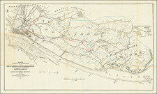
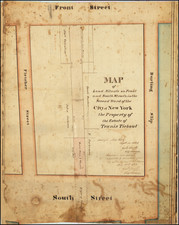
This map is a turn of the century facsimile of a 1788 map of the Bayard Farm by Casimir Goerck. This map shows one of the first examples of the now ubiquitous street grids of Manhattan. Goerck surveyed the farm so that the area could be as individual plots of land, but his streets had to eventually be altered to match with the surrounding city planning.
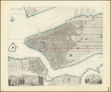
The map covers the exclusive retail and residential neighborhood of Soho, bounded by Broadway at the bottom, Bleeker at the right, Hancock (no longer extant) at the top, and Howard at the left. The map is oriented with west at the top left.
Bayard Farm
The map shows the 100-acre farm of Nicholas and Stephen Bayard, which was in their family since the 17th century. The land passed to Daniel Ludlow and Brockholst Livingston, as trustees. In 1789, they conveyed the land to several individuals, including Aaron Burr.
The present map covers the west section of the farm. This area has been mapped in many iterations, including notably by John Bute Holmes.