


|
||

|

|
|

|
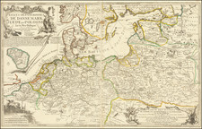
Important World War II-era mapping of Germany, clearly illustrating Nazi Germany's intention of taking over Czechoslovakia, coming immediately after the Anschluss in 1938.
The map was published by the Deutschen Verlag of Berlin. It is an attractively-colored road map of Germany including Austria.
The main intrigue of the map is its rendition of "Die Nationalitäten der Tschecho-Slowakei" or "The Nationalities of Czechoslovakia". These included German (and multi-lingual German), Slovak, Hungarian, Ukrainian, and Polish. But the intent is clear; there are substantial German populations in the Czech border areas and this necessitated the invasion of the country to join those populations with Germany.
A note in the lower right reads "With the new Reich borders."
A dramatic image and one of the more poignant maps for this pivotal moment in 20th-century history.
![Gibraltar to Berlin. [World War II Broadside Map.]](https://storage.googleapis.com/raremaps/img/small/83480.jpg)
![(Second World War - Balkans) Karte von Südosteuropa [Map of Southeastern Europe]](https://storage.googleapis.com/raremaps/img/small/90544.jpg)
![Daniae Regni Typus [with] Cimbricae Chersonese nunc Iutiae descriptio ..](https://storage.googleapis.com/raremaps/img/small/94423.jpg)
![Drink Norden Kaffe [Germany]](https://storage.googleapis.com/raremaps/img/small/91604.jpg)