|
||

|

|
|

|
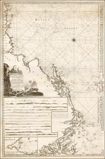
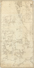
Attractive original antique map of the islands off of Stockholm published by Jacques Bellin in Paris in the latter half of the 18th century. The map focuses on the area around the islands of Orno and Uto, areas where important trade passes through but dangerous to navigate.
In the northernmost part of the map is Stockholm and shows soundings to get out to the open ocean, with various passages that can be taken. A note says that this passage is little-known by geographers and poorly recorded in English, French, and Dutch sea charts. This map is based on the accounts of a French navigator from a 1739 voyage.
Jacques-Nicolas Bellin (1703-1772) was among the most important mapmakers of the eighteenth century. In 1721, at only the age of 18, he was appointed Hydrographer to the French Navy. In August 1741, he became the first Ingénieur de la Marine of the Dépôt des cartes et plans de la Marine (the French Hydrographic Office) and was named Official Hydrographer of the French King.
During his term as Official Hydrographer, the Dépôt was the one of the most active centers for the production of sea charts and maps in Europe. Their output included a folio-format sea atlas of France, the Neptune Francois. He also produced a number of sea atlases of the world, including the Atlas Maritime and the Hydrographie Francaise. These gained fame and distinction all over Europe and were republished throughout the eighteenth and even in the nineteenth century.
Bellin also produced smaller format maps such as the 1764 Petit Atlas Maritime, containing 580 finely-detailed charts. He also contributed a number of maps for the 15-volume Histoire Generale des Voyages of Antoine François Prévost.
Bellin set a very high standard of workmanship and accuracy, cementing France's leading role in European cartography and geography during this period. Many of his maps were copied by other mapmakers across the continent.
![[ Skaraborgs Chiefdom, Southwestern Sweden ] Karta öfver Skaraborgs höfdingedöme . . . 1807](https://storage.googleapis.com/raremaps/img/small/99086.jpg)