|
||

|

|
|

|
Signed By the Captain of the USS Congress
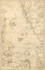
Rare English Sea chart, published in London by John Hamilton Moore.
The chart shows the region between Sweden and Denmark, extending to Rugen and the German coastline.
John Hamilton Moore (1738-1807) was a well-known teacher of navigation. He was born in Edinburgh, educated in Ireland, and subsequently joined the Royal Navy at Plymouth. In about 1770, Moore established a Nautical Academy in Brentford, Middlesex, and in 1772 he published The New Practical Navigator and Daily Assistant. Later he established himself at 127 Minories, near Tower Hill, where he taught navigation and carried on his business of selling maps and nautical instruments.
Provenance: Captain James N. Sever (1761-1845), Captain USS Congress; by descent in family.
Rarity
John Hamilton Moore charts are extremely rare. We note only 2 institutional examples (Bibliotheque National de France and Spanish National Archives).
![Thietmarsiae, Holsaticae Regionis Partis Typus [with] Oldenburg Comit.](https://storage.googleapis.com/raremaps/img/small/83583.jpg)
![[Denmark and southern Sweden]](https://storage.googleapis.com/raremaps/img/small/75156.jpg)
![[Stockholm] Vue du Port, du Chateau Royal, et d'une partie de la Ville de Stockholm](https://storage.googleapis.com/raremaps/img/small/77772.jpg)