|
||

|

|
|

|
Stock# 78370
Description
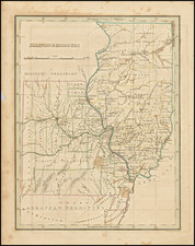
Attractive map of Missouri, published by Thomas Cowperthwait & Co.
The map is hand colored by counties and showing towns, roads, railroads, proposed rail lines, rail lines under construction, canals, steamship lines, etc. Includes township surveys and a host of other interesting details.
Just west of Missouri is Indian Territory, including over a dozen early Indian reservations.
![The City of St. Louis [with] The City of Chicago](https://storage.googleapis.com/raremaps/img/small/76144.jpg)