|
||

|

|
|

|
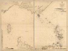
Two Charts of Cook's Australian Discoveries on his First Voyage
Great set of two French-language maps illustrating notable points during Cook's First Voyage, from the first French official account of the journey. These two maps appeared in the 1774 French translation of Hawkesworth's 1773 account of the voyages, with this plate being engraved by Robert Bernard following a map by Thomas Bowen.
The first of the two maps charts the entrance of the Endeavour River, showing the area around present-day Cooktown, Queensland. The entrance of the river is displayed with the locations of freshwater sources and various soundings. Cook was marooned in the vicinity of this river mouth for seven weeks after hitting part of the Great Barrier Reef. Cook and his crew explored the region while making repairs to the ship, and made contact with local aboriginal tribes.
The second of the two maps shows Botany Bay, in southern Sydney. Cook was the first European to visit the bay, and named the bay after the large amount of botanical specimens collected (though he first bestowed the name "stingray bay" due to the prevalence of these creatures). This map also shows fantastic detail, naming Cape Banks and Cape Solander.
Cook's First Voyage circumnavigated the globe starting in 1768 with two goals: to observe the transit of Venus from the South Pacific and to attempt to discover the Terra Australis Incognita. Along the way, Cook discovered many new locations, particularly in the South Pacific, New Zealand, and Australia.