


|
||

|

|
|

|
Stock# 77648
Description
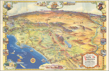
Very rare and attractive pictorial map of the Long Beach Peninsula, just north of the Columbia River estuary, in Washington. Showing this long spit of land in detail, the map names a great many place names and shows points of interest on the presque-isle.
Also included on the map are various photographs and an advertisement for Red's Cafe, in the southernmost part of the island.
This map was produced by Charles Muray, who, along with his wife Maureen Muray, produced several early pictorial maps of this part of Washington.
Rarity
We have located a single institutional holding of this map in the University of Washington library. We were unable to trace any further mentions of this map.
Condition Description
Minor wear at folds.
![[ Used by '49ers To Travel To California ] Map of Oregon and Upper California from the surveys of John Charles Fremont and others authorities drawn by Charles Preuss 1848](https://storage.googleapis.com/raremaps/img/small/100557.jpg)