


|
||

|

|
|

|
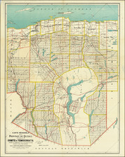
Extremely detailed and scarce 19th-century map of Quebec, showing the region to the north of the St. Laurence River between Ottawa and Troi-Rivieres, centered just west of Montreal.
The map shows the province divided into the comtés (effectively county) structure. Subdivisions are shown down to the township scale in less developed areas, to the north and west of the map. Railroads, cities, roads, and much more are all shown.
The map shows Quebec during a period of rapid demographic change when the population of Montreal was growing extremely rapidly. Montreal was the financial hub for the Dominion at the time, and the first city to rapidly modernize at the turn of the century.
Rarity
While maps with the same title were published relatively commonly in the 20th century, examples pre-dating 1900 are rather scarce. We find only 9 examples of the 1894 edition in OCLC.
![Partie du Cours du Fleuve de Saint Laurent depuis Quebec jusqu'au Cap aux Oyes [on sheet with] Carte du Cours du Fleuve Saint Laurent depuis Quebec jusqu'a la Mer en Deux Feuilles ... 1761](https://storage.googleapis.com/raremaps/img/small/55185.jpg)