|
||

|

|
|

|
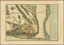
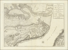
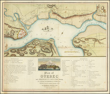
Attractive map of the city of Quebec focusing on the city's fortifications, published by Bellin in 1757.
The map is impressively and extensively detailed, focusing on the area around Basse Ville and showing many buildings, gardens, and more. The map includes a key at the right identifying the major buildings, and more.
This map appeared in Bellin's Petit Atlas Maritime, but was first prepared for Charlevoix's Histoire et Description Generale de la Nouvelle France.
In 1720 the Duke of Orleans sent the Jesuit scholar and explorer Pierre François-Xavier de Charlevoix to America to record events in New France and Louisiana and determine the best route to the Pacific Ocean. Charlevoix gathered geographic information from fur traders in Quebec and traveled through the Great Lakes and down the Mississippi River. After he returned to France, Charlevoix published his views on North America in his Histoire et description générale de la Nouvelle France, which has become one of the most important works on North America during the period prior to the French and Indian War.
Jacques-Nicolas Bellin (1703-1772) was among the most important mapmakers of the eighteenth century. In 1721, at only the age of 18, he was appointed Hydrographer to the French Navy. In August 1741, he became the first Ingénieur de la Marine of the Dépôt des cartes et plans de la Marine (the French Hydrographic Office) and was named Official Hydrographer of the French King.
During his term as Official Hydrographer, the Dépôt was the one of the most active centers for the production of sea charts and maps in Europe. Their output included a folio-format sea atlas of France, the Neptune Francois. He also produced a number of sea atlases of the world, including the Atlas Maritime and the Hydrographie Francaise. These gained fame and distinction all over Europe and were republished throughout the eighteenth and even in the nineteenth century.
Bellin also produced smaller format maps such as the 1764 Petit Atlas Maritime, containing 580 finely-detailed charts. He also contributed a number of maps for the 15-volume Histoire Generale des Voyages of Antoine François Prévost.
Bellin set a very high standard of workmanship and accuracy, cementing France's leading role in European cartography and geography during this period. Many of his maps were copied by other mapmakers across the continent.