


|
||

|

|
|

|
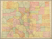
Colored To Show Colorado Forest Reserves
A fine example to the 1907 edition of Nell's seminal topographical map of Colorado.
This is one of the first commercial maps of Colorado to focus on Forest Reserves (blue). Agricultural lands are also highlighted in green.
Nell's Map of Colorado, first issued in 1880 and updated at least yearly thereafter, is without question the most important and detailed sequence of maps of Colorado issued in the latter half of the 19th and early 20the Century. The map meticulously revised and updated the map during this period or remarkable growth and change within the state of Colorado, depicting the geographical and topographical details of the state, including mountain elevations, Wagon roads, trails, and railroads both existing and proposed are depicted.
The regular updating of the map is clearly reflected in several noteworthy respects. The present edition notes in green the timber reserves set aside by the Timber Reserve Act of 1891 but does not yet depict the additional Timber Reserve lands created by Theodore Roosevelt during 1902. Similarly, the map pre-dates the creation of Adams County (incorporated November 15, 1902) and Denver County (incorporated November 15, 1902).
Nell worked on the 1871-1879 Wheeler Surveys and gained a significant amount of information from this work, which he ultimately employed in producing what is without doubt the best large format map of the state of the period, The map endured for nearly 30 years as the definitive map of Colorado. Nell notes Railroads, proposed Railroads, Wagon Roads, proposed Wagon Roads, Trails, County Seats, Post Offices, Villages, Townships subdivided and surveyed, Contour lines, Military Reservations, Private Grants, areas of each county, astronomical positions, arable lands, and a host of other details.
Louis Nell succeeded Thayer as the most important map maker in Colorado and continued publishing maps until the early 1900s.
An essential map for Colorado collectors.
![(Colorado Springs Photograph) [Original cabinet card albumen photograph of Tejon Street, Colorado Springs, looking south toward Cheyenne Mountain]](https://storage.googleapis.com/raremaps/img/small/87515.jpg)
