This item has been sold, but you can enter your email address to be notified if another example becomes available.


|
||

|

|
|

|
Stock# 77112
Description
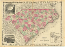
Rare large format antique lithographed map of South Carolina, published by G.W. & C.B. Colton in New York in 1871.
The map is a detailed, relatively large-format treatment of the State of South Carolina during Reconstruction, with the 30 counties individually colored and named. Railroad lines are illustrated, as are roads, swamps, etc.
A highly desirable 19th-century American map for South Carolina collectors.
Rarity
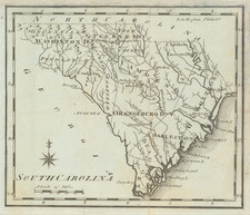
These large format Colton maps are surprisingly rare. No copies are recorded in OCLC. We find an example of the 1869 edition for sale at UT Arlington. OCLC lists three at the British Library; University of Illinois, Chicago; Yale University; University of South Carolina; South Carolina Historical; and Wisconsin Historical.
Condition Description
Original hand-color. Folding into original folder. Some wear at folds, most notably with small loss at fold intersection several inches north of Charleston. This could be easily repaired for a small sum, rendering the map VG+.
![[Revolutionary War Plans of New York, Boston, Charleston, Delaware River to Philadelphia & Havana] Various Plans and Draughts of Cities, Towns, Harbours &c . . .](https://storage.googleapis.com/raremaps/img/small/83450.jpg)
![[French Colonization in Florida and the Southeast] La Floride Francoise Dressee sur La Relation des Voiages que Ribaut, Laudonier, et Gourgues y ont faits in 1562, 1564 et 1567 . . .](https://storage.googleapis.com/raremaps/img/small/91072.jpg)