


|
||

|

|
|

|
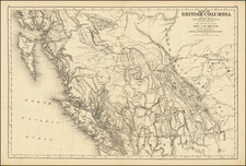
The Opening of the Canadian Prairies for Agricultural Settlement
Fine large map of central and Western Canada, lithographed by John Arrowsmith in London to display the results of the 1858 Assiniboine and Saskatchewan Exploring Expedition, lead by Henry Youle Hind, and the British North American Ex. Ex., lead by John Palliser.
This fantastic map provides a perfect representation of the Arrowsmith family's highly precise, scientific, and authoritative style of mapmaking. West of Lake of the Woods, the map cites three different authorities that they rely on for each region: Hind between Lake of the Woods and the Forks of the Saskatchewan (apparently near Fort a la Corne); Palliser between the Forks and the Rocky Mountains; and the 1859 Arrowsmith Map of British Columbia and Vancouver Island, etc, published by Arrowsmith for the governmental blue book.
The map is highly detailed, based as it is on the foremost sources of the day. Most notable on the map is the distribution of "Rich Pasturage," colored in yellow, that stretches from St. Vincent, Minnesota, to the base of the Rock Mountains at the head of the South Saskatchewan River in a bow-shaped form. Lakes, rivers, forts, and more are all shown.
The Palliser and the Hind expeditions each sought to explore the Canadian West in a new scientific manner, one that was mirrored by the Warren and Raynolds expeditions south of the border. Each expedition had botanists, geologists, and other specialized scientists who were able to provide new insights into the lands they explored. These expeditions not only provided scientific knowledge but also agricultural and mineralogical insights of economic importance. The Hinde and Palliser expeditions were particularly notable, as shown on this map, for recognizing the great agricultural potential of central Canada, an area that has today become the breadbasket of the confederation.
The Arrowsmiths were a cartographic dynasty which operated from the late-eighteenth century to the mid-nineteenth. The family business was founded by Aaron Arrowsmith (1750-1823), who was renowned for carefully prepared and meticulously updated maps, globes, and charts. He created many maps that covered multiple sheets and which were massive in total size. His spare yet exacting style was recognized around the world and mapmakers from other countries, especially the young country of the United States, sought his maps and charts as exemplars for their own work.
Aaron Arrowsmith was born in County Durham in 1750. He came to London for work around 1770, where he found employment as a surveyor for the city’s mapmakers. By 1790, he had set up his own shop which specialized in general charts. Arrowsmith had five premises in his career, most of which were located on or near Soho Square, a neighborhood the led him to rub shoulders with the likes of Joseph Banks, the naturalist, and Matthew Flinders, the hydrographer.
Through his business ties and employment at the Hydrographic Office, Arrowsmith made other important relationships with Alexander Dalrymple, the Hudson’s Bay Company, and others entities. In 1810 he became Hydrographer to the Prince of Wales and, in 1820, Hydrographer to the King.
Aaron Arrowsmith died in 1823, whereby the business and title of Hydrographer to the King passed to his sons, Aaron and Samuel, and, later, his nephew, John. Aaron Jr. (1802-1854) was a founder member of the Royal Geographical Society (RGS) and left the family business in 1832; instead, he enrolled at Oxford to study to become a minister. Samuel (1805-1839) joined Aaron as a partner in the business and they traded together until Aaron left for the ministry. Samuel died at age 34 in 1839; his brother presided over his funeral. The remaining stock and copper plates were bought at auction by John Arrowsmith, their cousin.
John (1790-1873) operated his own independent business after his uncle, Aaron Arrowsmith Sr., died. After 1839, John moved into the Soho premises of his uncle and cousins. John enjoyed considerable recognition in the geography and exploration community. Like Aaron Jr., John was a founder member of the RGS and would serve as its unofficial cartographer for 43 years. Several geographical features in Australia and Canada are named after him. He carried the title Hydrographer to Queen Victoria. He died in 1873 and the majority of his stock was eventually bought by Edward Stanford, who co-founded Stanford’s map shop, which is still open in Covent Garden, London today.
![[ Michigan & 3 Great Lakes ] Amer. Sep. No. 42 Haut Canada Et Michigan](https://storage.googleapis.com/raremaps/img/small/98409.jpg)