|
||

|

|
|

|
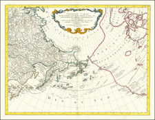
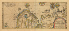
The Far North of North America
Fine example of Lizar’s map of Canada, Alaska and the Polar Regions, made in a period of intense Artic exploration.
The map includes the Pacific Northwest of the United States, the Rocky Mountains, Russian Alaska, and all of Canada. Greenland is shown connected to Canada via Baffin Bay. Coastlines in the far north are unfinished, as those areas remained little or unexplored by Europeans.
The emphasis of the map is on the search for the Northwest Passage, either overland via river or in the open ocean via an Arctic seagoing route. The forts of the Hudson’s Bay Company dot James and Hudson’s Bays, and the area to the west is filled with rivers and lakes explored by Company employees, scouted by fur traders, or reported upon by Native informants. The names of various First Nations groups are included.
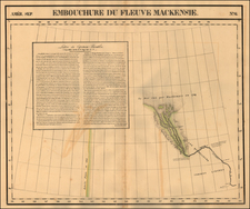
One of the expeditions chronicled here is that of Alexander Mackenzie. Mackenzie is the first known person to cross North America from east to west north of Mexico; he accomplished this in 1792-3, a dozen years before the more famous Lewis and Clark. However, his presence is noted most clearly on this map with the Mackenzie River, which leads to the Arctic Ocean. In 1788, while working for the North West Company, Mackenzie co-founded Fort Chipewyan and then traveled northwest, eventually reaching the Artic Ocean in July 1789.
To the north, recent open-ocean voyages and overland missions led by the Royal Navy have added to the place names and geography. These included that of John Ross, who made it to Baffin Bay and Lancaster Sound. Ross thought the Sound only an inlet, and went no further. He was followed by a voyage led by Edward Parry, who had been with Ross, in 1819. Parry wintered at Melville Island, gaining him an Admiralty prize for passing the 110th meridian west. On his second voyage, 1821-23, he probed the far north reaches of Hudson’s Bay. On his third voyage, of 1824-25, he searched for the Northwest Passage in the Prince Regent Inlet. Ross also returned to the Arctic, but neither man located the passage.
John Franklin led overland expeditions in 1819-1822 and 1825-27. While the first voyage was marked by privation, the second saw Franklin and his men chart over 1,000 miles of Arctic coastline.
The treatment of Western Territory (Oregon Territory) is quite nice topographically. It correctly places the Fraser River and the Columbia, and shows a credible course of the Missouri River and tributaries.
A "supposed river" from the Great Salt Lake region to San Francisco Bay remains. Interestingly, it shows the “54-40 or Fight” border.
This is an excellent regional map with rich detail for the period.
The creation of Oregon Territory and State
Since the publication of James Cook’s third voyage account, and compounded by the reports of the Lewis & Clark expedition, the Pacific Northwest had been a region of interest and speculation for many Americans in the early nineteenth century. It supposedly held rich farmlands ripe for European settlement. In the early nineteenth century, the only Europeans in the area were those who came by ship, like Cook, or those who travelled overland from the areas that are now California (Spaniards and Mexicans), Alaska (Russians), and Canada (British).
Again spurred by Cook, many came to take advantage of the lucrative fur trade, with the Hudson Bay Company (HBC) as the most famous of the several companies who attempted to monopolize the fur business. In 1818, Britain and the United States, eager to shut out competition and to lock down the promise of the region, agreed by treaty to share sovereignty.
Over time, however, this alliance frayed in light of continued growth by the HBC and pressure from United States settlers eager to gain recognition from the US government. The boundary was renegotiated in 1826; the 49th parallel was discussed but no resolution was reached.
In 1812, Robert Stuart discovered a route over the Continental Divide, South Pass, which was safe for wagons to cross. Stuart, who worked for the Pacific Fur Company, had started at the Columbia River and journeyed east and over South Pass into what is now Wyoming; he proved it possible to get over both the Blue and the Rocky Mountains via wagon.
In the 1830s, settlers began to follow the route west, inspired by books like Hall Jackson Kelly’s A Geographical Sketch of that Part of North America called Oregon (1830) and his General Circular to All Persons of Good Character Who Wish to Emigrate to the Oregon Territory (1831). The first wagon train, organized by Nathaniel Wyeth and guided by William Sublette, a fur trader, made the crossing in 1831. Three farmers from that group became the first Americans to settle in Oregon, joining British subjects, mostly HBC employees, already farming in the Willamette Valley. Wyeth organized another wagon train in 1834; it did not succeed in shifting a large number of people to Oregon, but one of its members, the missionary Jason Lee, did stay and started to call others to join him.
Inspired by Lee and other missionaries like Marcus Whitman, the United States government took up the subject of Oregon’s status. In 1838, Senator Lewis Linn of Missouri proposed a bill that would authorize settlement. Linn proposed several similar bills between 1838 and 1843, his voice forming the core of a rising clamour to integrate Oregon into the United States. A county in Oregon would eventually be named for him.
The House Committee on Foreign Affairs also took up the topic of Oregon Country. Caleb Cushing, a Representative from Massachusetts, began arguing for the US’s claim to Oregon by right of first discovery. In January 1839, he led the Foreign Affairs Committee to issue a report that favored the creation of a military presence in Oregon, in order to defend the US’s claim to the land and its use. Included in the report were letters from those already living in Oregon who were desperate for a governor and magistrate; they wanted reassurance that their new farms were legal claims. The reports were convincing; the House ordered 10,000 extra copies to be printed and distributed to the American people.
The reports must have been effective, along with a flurry of guidebooks and maps. The 1840s was the boom decade of the Oregon Trail. Between 1840 and 1860, 400,000 journeyed overland on the 2,000 mile Oregon Trail; they formed one of the largest mass migrations in American history. By the late 1830s, the American settlers began to outnumber the British.
In the US Presidential Election of 1844, James K. Polk ran on a platform that used the slogan “54°40 or Fight!” This referred to the boundary line to be established between British Canada and the United States. This parallel was just below the boundary of Russian settlement in Alaska and effectively shut the British out of much of the Pacific Northwest Coastline.
Polk was elected but quickly became embroiled in another border dispute to the south, the Mexican-American War (1846-8). Rather than fighting on two fronts, Polk tried to negotiate the northern border with the British. By this time, Americans outnumbered the British in Oregon six to one. The British, eager to protect the forts they had built via the HBC, wanted a parallel at the 42nd parallel. Polk compromised on the 49th, precisely the parallel shown on this map. The border treaty was signed in June 1846.
Initially, the land was left unincorporated. However, on November 29, 1847, Marcus Whitman, his wife Narcissa, and their children were killed by Cayuse people during an attack on the mission. The Cayuse accused Whitman of poisoning Cayuse who had been in his care. Whitman had guided one of the first large wagon trains west and was well known to lawmakers in Washington D.C. Outraged by the violence, but not, presumably, by the alleged poisonings of the Cayuse, Congress began to organize to have Oregon brought under direct US control.
Oregon was officially incorporated as a US Territory on August 14, 1848. In 1853, the northern portion was carved out and became Washington Territory. In 1859, the southwestern portion of the Territory became the state of Oregon. The rest of the Territory eventually became parts of the states of Idaho, Montana, and Wyoming.
The Lizars were a Scottish family of engravers and printers who produced many views and maps. Daniel Lizars Sr. (1754-1812) was the son of a shoemaker, but he apprenticed with Andrew Bell, a printer and engraver. Lizars set up his own printworks near St. Giles Cathedral and took on his own apprentices, including George Bartholomew, whose son John would go on to found the important mapmaking firm later know as John Bartholomew & Son Ltd.
Daniel Sr. had three sons: Daniel Jr., John, and William Home. He also had a daughter, Jane Home. Daniel Jr. (1793-1875), the youngest of the boys, apprenticed in his father’s shop alongside George Bartholomew. When his father died in 1812, Daniel Jr. took over much of the business, expanding it and specializing in maps. The company went bankrupt in 1832, however, and Daniel emigrated to Canada.
John Lizars (1792-1860), the middle son, studied medicine and became Professor of Surgery at the Royal College of Surgeons of Edinburgh, as well as senior surgeon at the Royal Infirmary of Edinburgh.
William Home Lizars (1788-1859), the eldest, also apprenticed in his father’s shop. After learning engraving, William entered the Trustees’ Academy to learn under John Graham. He was a skilled painter and artist. When his father died, and after his Daniel Jr. left, he carried on printing and invented a method of etching that looks like wood engraving.
![(Strait of Magellan) Freti Magellanici ac novi Freti vulgo Le Maire exactissima delineatio. [The most exact delineation of the Strait of Magellan and the new Strait, commonly known as Le Maire.]](https://storage.googleapis.com/raremaps/img/small/99612.jpg)