|
||

|

|
|

|
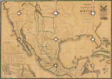
Survey of the Fine Early Maps of California
A historically important depiction of the 5 most influential cartographic depictions of California, showing the evolution of how California was mapped between 1604 and 1767.
The earliest map is (upper right corner) based upon a manuscript map by Mathieu Neron Pecci, drawn in Florence in 1604. This map also forms the basis of a map popularized in 1770 by Rigobert Bonne.
The second map is Nicholas Sanson's map of California as an Island, based upon his larger map of 1656. This map was probably the single most influential projection of California as an Island.
The third map (lower right) is a portion of Guillaume De L'Isles map of America, published in 1700. While not truly peninsular in nature, it was influential in the shift back toward depicting California as a Peninsula.
The fourth map (upper center) is a portion of Fra. Eusebio Kino's map, generally credited with being the map which dispelled California as an Island myth. Issued in 1705, the map is based upon Father Kino's overland expedition from the mainland to the top of the Gulf of Cortez.
The fifth map is one of the most interesting and enduring maps of California and Baja (left side). Initially issued by the Society of Jesuits in 1767, it was popularized by Isaak Tirion and was perhaps the most interesting of all maps of Baja California in the 2nd half of the 18th century.
This map was 1 of 10 maps to appear in the Supplement to Diderot's monumental encyclopedia, one of the most influential and widely distributed works of the second half of the 18th century. Diderot's goal was to examine and display the popular geographical conceptions of several different parts of the world where the knowledge of the region's geography was still largely unknown and evolving. Other maps treat the Northwest Passage, Northeast Passage and the NW Coast of America, among other topics.
A marvelous amalgam and an essential map for California collectors.
![[Baja California--Cabo San Lucas] Amer. Sep. No. 58 Partie De La Vielle Californie [and] Amer. Sep. No. 63 Partie De La Vielle Californie](https://storage.googleapis.com/raremaps/img/small/100744.jpg)