


|
||

|

|
|

|
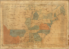
Map of the Louisiana Purchase by the French Negotiator for the 1803 Treaty
Uncommon map of the United States showing the Louisiana purchase, with interesting printed annotations pertaining to the Oregon Question and historical territorial claims. The map was published in 1829 as part of François Barbé-Marbois's Histoire de la Louisiane et la cession de cette colonie par la France aux Etats-Unis.
The map shows the division of the United States prior to the Louisiana Purchase when it was bounded by the Mississippi River. Michigan and Minnesota are included as part of a Northwest Territory, and a complex boundary is shown in Lake of the Woods. Florida is still shown as Spanish and comprising West Florida, although the later boundaries of Mississippi and Alabama are dotted in.
Detail in the Louisiana Territory is interesting. Notes mention how old maps show the Louisiana Purchase stopped at the 110 degrees marker. Mentions are made of contested territory between the English and the Americans that were supposed to be resolved in 1828 but were not. "Old" and "New" Mexico are shown, and Texas is named.
François Barbé-Marbois had a fascinating personal history, being involved in the French Revolution and being deported to French Guiana. He was later chosen as the French Treasury Minister, and he negotiated the Louisiana Purchase on behalf of Napoleon. He would later write about his experiences and design the presented map.
Barbé-Marbois was also directly responsible for the famous Jefferson text Notes on the State of Virginia, which was prompted when he wrote to the governor of all thirteen colonies to ask about each state's geography, resources, history, and government.

![[Early Montana Territory Shown Above Idaho] Johnson's New Military Map of the United States Forts, Military Posts & all the Military Divisions with Enlarged Plans of the Southern Harbors . . . (Shows Military Departments)](https://storage.googleapis.com/raremaps/img/small/93868.jpg)
![The United States of America Confirmed By Treaty 1783 [shows Franklinia]](https://storage.googleapis.com/raremaps/img/small/84491.jpg)
![United States [rare variant edition]](https://storage.googleapis.com/raremaps/img/small/83279.jpg)