|
||

|

|
|

|
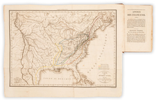
The First Atlas Map To Show The United States From Coast To Coast
Nice example of Lucas' map of the United States, one of the earliest obtainable maps to show the United States extending from coast to coast.
While the map normally appears as an atlas sheet from Field Lucas's Atlas, the present example of the map was issued with a rare memoir published by the City of New York by Cadwallader Colden.
This is the second state of Lucas' map, with Arkansas revised to show it in a configuration which lasted from only November 15, 1824 (when the Reduction Act of 1824 shrunk its boundaries) to 1828 (when the Reduction Act of 1828 again changed its shape to its modern configuration).
While many of the boundaries of the Eastern States are formed much of the west is comprised of the Oregon Territory and Mexico.
Sections of Oregon Territory are labeled with Indian names including Shiennes, Sioux, Black Foot, Iaways, and Konzas.
The boundary between Canada and the US is not definite from the Rocky Mountains to the Pacific Coast, reflecting the agreement reached between the US and Great Britain to leave this region with an undefined border. North West Territory contains much of present day Wisconsin and some of Minnesota.
Arkansas Territory includes much of present day Oklahoma. Missouri is not yet fully formed and Michigan Territory extends into what is now Eastern Wisconsin. Includes an early representation of Missouri, which became a state in 1821.
The map follows the Melish's 1816 map, including early Lewis & Clark details. In California, the mythical rivers from San Francisco toward the two Salt Lakes remain. The treatment of the Western US Territories is excellent for the period.
The first Coast to Coast US map to appear in an American Atlas. Wheat's omission of this map attests to its rarity.
Fielding Lucas, Jr. (1781-1854) was a prominent American cartographer, engraver, artist, and public figure during the first half of the 19th century.
Lucas was born in Fredericksburg, Virginia and moved to Philadelphia as a teenager, before settling in Baltimore. There he launched a successful cartographic career. Lucas's first atlas was announced in early- to mid-1812, with production taking place between September 1812 and December of 1813, by which point the engravings were complete. Bound copies of the atlas -- A new and elegant general atlas: Containing maps of each of the United States -- were available early in the next year, beating Carey to market by about two months. Lucas later published A General Atlas Containing Distinct Maps Of all the known Countries in the World in the early 1820s.
![[Shows Franklinia!] Charte Der XV Vereinigten Staaten von Nord-America Nach Murdochischer Projection . . . F.G. Gussefeld . . . 1804](https://storage.googleapis.com/raremaps/img/small/91386.jpg)
![Die Vereinigten Staaten von Nord Amerika (Ostlicher Theil) [New York City Inset]](https://storage.googleapis.com/raremaps/img/small/62359.jpg)