


|
||

|

|
|

|
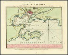
Attractive original antique map of the town and harbor of Toulon, in southern France.
The map shows the city, its fortifications (on land and at sea), and other coastal towns including La Seyne-sur-Mer. Useful navigational detail is included, namely soundings, coastal topography, and the locations of undersea sandbars. This map originally appeared in Bellin's Le Petit Atlas Maritime.
Toulon is an important military town on the Mediterranean coast. The naval port dates back to 1494, when it was constructed under Charles VIII, and it remains an important military center to this day. The city can credit this position to its excellent harbor, located at the end of relatively large bay.
Jacques-Nicolas Bellin (1703-1772) was among the most important mapmakers of the eighteenth century. In 1721, at only the age of 18, he was appointed Hydrographer to the French Navy. In August 1741, he became the first Ingénieur de la Marine of the Dépôt des cartes et plans de la Marine (the French Hydrographic Office) and was named Official Hydrographer of the French King.
During his term as Official Hydrographer, the Dépôt was the one of the most active centers for the production of sea charts and maps in Europe. Their output included a folio-format sea atlas of France, the Neptune Francois. He also produced a number of sea atlases of the world, including the Atlas Maritime and the Hydrographie Francaise. These gained fame and distinction all over Europe and were republished throughout the eighteenth and even in the nineteenth century.
Bellin also produced smaller format maps such as the 1764 Petit Atlas Maritime, containing 580 finely-detailed charts. He also contributed a number of maps for the 15-volume Histoire Generale des Voyages of Antoine François Prévost.
Bellin set a very high standard of workmanship and accuracy, cementing France's leading role in European cartography and geography during this period. Many of his maps were copied by other mapmakers across the continent.
![[Avignon] Le Vray Pourtraict de la Ville de D Avignon](https://storage.googleapis.com/raremaps/img/small/73988.jpg)
![[Auvergne] Description du pays d'Auvergne](https://storage.googleapis.com/raremaps/img/small/74098.jpg)