|
||

|

|
|

|
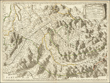
Scarce map of the Auvergne region of France, from De Belleforest's French edition of Sebastian Munster's Cosmographia.
Oriented with west at the top, the map shows the river system of the Allier with Clermont-Ferrand in the background, and includes 4 coats of arms The woodcut is based on the map of Gabriel Siméoni, published in Lyon in 1560, which appeared in his Dialogus Pius et speculativus. At the time of its publication, it was one of the earliest printed provincial maps of a French region. Abraham Ortelius would later use this map as the source for his map of the region, re-orienting it with north at the top.
In 1544, the scholar and geographer Sebastian Munster published his Cosmographia, one of the most important an influential works of its type in the16th century
Belleforest's work is an adaptation of . Sébastien Münster's Cosmographia first published in Basel in 1544. As Münster had been mainly concerned with Germany, the chapters on France had to be rewritten in order to make the work more interesting to a French audience. Belleforest had sent local elites in major cities across the country a request for information on regional history and geography. As a good philologist, he relied above all on recognized textual authorities, which set him against André Thevet, who published his Cosmographie universelle in 1575. In the vehement controversy between the two authors, Thévet says of Belleforest that he "never traveled by name more "Than the Owls who repaired in the Aqueduct of Athens, or at the Byzantine Hippodrome". Belleforest replied to the accusations by arguing that a single man could never visit all regions of the earth and that a traveler could easily lie, for lack of possibilities to verify the veracity of his account "
![[ Provence ] Carte de Provence](https://storage.googleapis.com/raremaps/img/small/103397.jpg)
![[Lyon]. Description Au Naturel De La Ville De Lyon E Paisages Alentour D'Icelle](https://storage.googleapis.com/raremaps/img/small/42402.jpg)