
This item has been sold, but you can enter your email address to be notified if another example becomes available.


|
||

|

|
|

|
Stock# 76453
Description
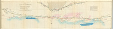
Fascinating map of South Africa, illustrating the routes of important early travellers in the region in the first decades of the 19th Century.
The map is apparently keyed to the text in volume 2 of Carl Ritter's Geography work. Carl Ritter (1779 – 1859) was a German geographer. Along with Alexander von Humboldt, he is considered one of the founders of modern geography.
The map illustrates the routes of the following travellers:
- Henry Lichtenstein in 1805
- John Cambell in 1812
- John Cambell in 1819
Includes a large inset of the area around False Bay and Table Bay.
![[Luanda, Angola] Eroberung der Statt Loando de Sanct Paolo in Angola in Africa. Gelegen](https://storage.googleapis.com/raremaps/img/small/85194.jpg)
![South Africa [Map Your Holiday in South Africa]](https://storage.googleapis.com/raremaps/img/small/96622.jpg)
![Juta's Map of South Africa From The Cape To The Zambesi Compiled from the best available Colonial and Imperial Information Including The Official Cape Colony Map By The Surveyor General, Cape Town, Dr. T.Hahn's Damaraland, And E.C.Selous' Journals & Sketches &c. New and Revised Edition .. . . 1889 [2 Sheets in slipcase]](https://storage.googleapis.com/raremaps/img/small/85389.jpg)