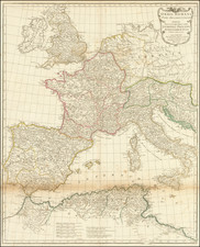
|
||

|

|
|

|
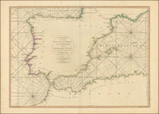
Attractive map of the Mediterranean published by Nicolas Bellin in his Le Petit Atlas Maritime. The map stretches from the Straits of Gibraltar in the west to the Syrian and Egyptian coasts in the east. The majority of the Black Sea is also visible.
Numerous coastal cities are denoted, although inland detail is limited. Relief is shown pictorially. The Adriatic Sea is named the "Gulf of Venice," while the Black Sea is also named "The Euxinic (sulfurous) Bridge." Malta and Cyprus are shown. Several kingdoms, such as the Kingdom of Algiers or the Kingdom of Tripoli, are shown in northern Africa.
Jacques-Nicolas Bellin (1703-1772) was among the most important mapmakers of the eighteenth century. In 1721, at only the age of 18, he was appointed Hydrographer to the French Navy. In August 1741, he became the first Ingénieur de la Marine of the Dépôt des cartes et plans de la Marine (the French Hydrographic Office) and was named Official Hydrographer of the French King.
During his term as Official Hydrographer, the Dépôt was the one of the most active centers for the production of sea charts and maps in Europe. Their output included a folio-format sea atlas of France, the Neptune Francois. He also produced a number of sea atlases of the world, including the Atlas Maritime and the Hydrographie Francaise. These gained fame and distinction all over Europe and were republished throughout the eighteenth and even in the nineteenth century.
Bellin also produced smaller format maps such as the 1764 Petit Atlas Maritime, containing 580 finely-detailed charts. He also contributed a number of maps for the 15-volume Histoire Generale des Voyages of Antoine François Prévost.
Bellin set a very high standard of workmanship and accuracy, cementing France's leading role in European cartography and geography during this period. Many of his maps were copied by other mapmakers across the continent.
![[ Italian Mediterranean Coastline ] Hydrographica descriptio, in qua ore maritime Italiae a monte Argentato Napolim usque, promontoria item & portus, ajacentes insule...](https://storage.googleapis.com/raremaps/img/small/97984.jpg)
![Chart of the Mediterranean Sea [Cyprus]](https://storage.googleapis.com/raremaps/img/small/72759.jpg)
![[Early Fascimile of the Disputed Christopher Columbus Portolan Chart]](https://storage.googleapis.com/raremaps/img/small/66588.jpg)