


|
||

|

|
|

|
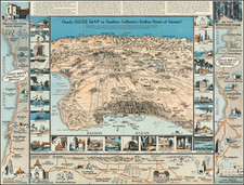
Affirmation of the Claim of a Luiseño Indian To Rancho Little Temecula
Finely executed survey map of Rancho Little Temecula, "approved January 8, 1873 [by] Willis Drummond Commissioner of the General Land Office."
Located south of Rancho Temecula (confirmed to Luis Vignes, aka Jean Louis Vignes, the first California winemaker) and Rancho Pauba, this small rancho is one of the very few Mexican-California Ranchos granted to an indigenous person and one of even fewer to have had the claim upheld and the land patented to such claimant. In this instance, the successful claimant, Pablo Apis, was an elder of the Luiseño people, who had been baptized at the Mission San Luis Rey, shortly after its founding in July 1798, and had risen to become a community leader.
The present survey, completed at about the time the land grant was finally patented (posthumously) to Apis and his heirs, provides a remarkable snapshot of the Luiseño, Pechanga and American communities in Temecula in the early 1870s and preserves the location of many early landmarks long since lost to time.
Among the other important early locations on the map are the first inland Southern California post office (opened April 22, 1859 at John Magee's store) which was open until the Civil War and the location of the Butterfield Overland Stage Route and stop (again at Magee's store).
The details on the map listed below are also highlighted in bold letters in the description below, in order to illustrate their importance in the early history of region. These include the homes of Pablo Apis and his family, the Indian Reservoir (Mill Pond) which served as the major crossing for early emigrants and later Butterfield Overland Stage Route (stopping at Magee's Store) and other important landmarks in the early history of Temecula Valley up to the early 1870s.
- Road to Fort Yuma
- Temecula Creek
- San Luis Rey Road
- Mill Pond on Temecula Creek
- Planting Ground of Pablo Apis
- Ruins of Adobe House
- Grave Yard
- [Louis] Wolfs Store and Yard (a Stage Coach stop after 1861 and post office beginning in 1870)
- Ruins of Smoke House
- J Magee's Store (Butterfield Overland Stage Stop)
- [David] Holman & [Charles] Seaman - Formerly Apis House (sold to Holman and Seaman in 1859)
- Trail in Ravine (2)
- Vasques House
- Sheep Corral
Pablo Apis and Little Rancho Temecula
Rancho Little Temecula was a 2,233-acre Mexican land grant in present-day Riverside County, California given in 1845 by Governor Pío Pico to Pablo Apis. The grant was one of the few held by indigenous people. The grant is south of present-day Temecula and is bordered on the north by Temecula Creek.
Pablo Apis (1792–1854) was a Luiseño Indian, born at Guajome village near Oceanside. In 1798, he was among the first indigenous people baptized at the Mission San Luis Rey. Apis learned to read and write in Spanish and eventually rose to a position of leadership in which he was the principal spokesman for the local Luiseños. After the missions became secularized in the 1830s, many indigenous people came to live in Temecula. Apis was one of the Luiseño leaders who fought to keep the Californios from taking control of the mission. Apis was imprisoned for a short time in 1836 by Pío Picof for objecting to Pico's management of the mission.
In 1843, Apis was given the Temecula area, including the established Luiseño village center, by Father Jose Maria Zalvidea, a priest briefly in control of the former mission lands. Zalvidea appears to have undertaken an initiative to grant native peoples their village lands, including grants of Rancho Guajome and Rancho Cuca. Apis applied for formal ownership of Rancho Little Temecula 1845 in return for his assistance to the mission.
With the cession of California to the United States following the Mexican–American War, the 1848 Treaty of Guadalupe Hidalgo provided that the land grants would be honored. As required by the Land Act of 1851, a claim for Rancho Little Temecula was filed with the Public Land Commission in 1852, but American settlers opposed indigenous people owning land, and used a variety of procedural tactics to impede the claim's progress.
Sometime in late 1853 or early 1854, around the time the Land Commission rejected his claim, Pablo Apis died at about 61 years of age. In 1856, Isaac Williams, the holder of Rancho Santa Ana del Chino to the north (and related to Apis through marriage), helped push an appeal through the courts, which was decided in favor of Apis's daughter and Williams's wife, Maria Antonio Apis. The court decision proved that an Indian could own land in California in the 1850s.
In the late 1850s, the Apis adobe served as the Temecula station of the Overland Mail Company’s transcontinental stage line and as a store. As late as 1865 it was still a store and, evidently, the social center of the Temecula community when it was the subject of a sketch by artist Edward Vischer. Sometime before 1872 it was apparently abandoned.
In 1872, Louis Wolf, pioneer storekeeper of Temecula, acquired the Apis grant. The grant was officially patented to Pablo Apis in 1873. In 1873, Juan Murrieta, Domingo Pujol and Francisco Sanjurjo purchased the grant from Wolf. Two years later, the San Diego County Sheriff forced the indigenous people from their homes in Temecula and led them to what is now known as the Pechanga Indian Reservation.
Pablo Apis In The Temecula Valley
When Pablo Apis first moved onto his land grant at Temecula in 1843, he lived in an adobe house in an unspecified location. Sometime later in the 1840s he built and occupied his second house, which is now known as the Apis Adobe. This second house was already there during the Gold Rush in late summer of 1849. In January 26, 1850, Benjamin Hayes passed through Temecula and described it and the Apis Adobe:
A vineyard is being set out here. There is a pear and peach orchard. The bottoms of the creek occasionally spread out to the width of near a mile. Thirty or more thatch wigwams; the Chief lives in an adobe house, with an adobe corral around it; his house has several rooms. There are some other adobe houses in the village.
The Gila Trail coming from the Colorado River ran along the south bank of Temecula Creek until reaching Temecula village, where hills on the south bank narrowed the valley some and the Indians’ dam made it easier to cross. This route required the travelers to pass the Apis Adobe.
The peace and relative prosperity of Temecula were suddenly jeopardized in November 1851, when Cahuilla and Cupeño Indians living in and near Warner’s Ranch, led by Antonio Garra of Cupa (Warner Springs), tried to unite all of the tribes of Southern California to drive out the Americans. Known as the Garra Revolt, the action was blamed on the levying of taxes upon the Christianized Indians by the sheriff of San Diego County.
The revolt began when the Indians killed four invalids at Warner’s Hot Spring and two of Warner’s employees as well as two groups of sheepherders crossing the desert. Pablo Apis wrote the alcalde of San Diego on November 21 that “…we (the Temecula village) wish to leave here for the Mission of San Luis Rey…until things are settled.” Apis also wrote to Abel Stearns in Los Angeles, who had cattle at the Laguna (Lake Elsinore), advising him to move his herds to safety at San Luis Rey. The Luiseños gathered at the Mission and remained there until the end of December when the danger had passed, at which time Pablo and the Indians returned to Temecula. The American populace of Southern California gratefully acknowledged Apis’ role in keeping the Luiseño out of the conflict. In a brief campaign in late December, the Army captured and executed some of the leaders of the revolt at Los Coyotes village east of Warner’s Ranch and a volunteer force from San Diego burned the village of Cupa (also know as Agua Caliente).
On January 5, 1852, the Treaty of Temecula was signed at the Apis Adobe. The treaty provided for a reservation to protect the Indians and their lands from American and California incursions, for the Indians to cede all other lands to the government, and assistance to the Indians to establish agriculture for their sustenance. In recent years, writers appear to have been considerably confused as to where the Treaty was signed. Contemporary newspaper reports mention “Apis’ Rancho” and “Pablo’s private room,” providing evidence that the event occurred at the Apis Adobe. Field notes of U.S. Deputy Surveyor Henry Washington in 1853 show at Temecula only the Indian village and a large dwelling house, which would be the Apis Adobe.
Despite the lack of other buildings at Temecula in 1853, others have stated that the treaty was signed at either Magee’s Store or at Wolf’s Store. However, there is no evidence that either of these buildings existed at that early date. Magee’s Store, a quarter mile to the west of the Apis Adobe, appears to have been built after 1857 and Wolf’s Store, a little farther to the northwest on the north bank of Temecula Creek, was built in the late 1860’s.
Rarity
The map is apparently a unique survival.
![[Historical Map of Julian, California]](https://storage.googleapis.com/raremaps/img/small/94157.jpg)

![Camp Pendleton [cover:] Two Weeks With The Marines in California](https://storage.googleapis.com/raremaps/img/small/92525.jpg)
![(San Diego) Map of the Water Front of San Diego on San Diego Bay Showing the Line of Mean High Tide [National City to Old Town] [with] Map of the Water Front of San Diego on San Diego Bay Showing the Line of Mean High Tide [Midway District to Point Loma]](https://storage.googleapis.com/raremaps/img/small/95403.jpg)