|
||

|

|
|

|
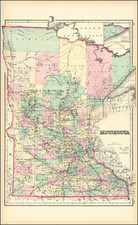
This is one of the classic Twin Cities maps, often reproduced online, but increasingly difficult to find in original examples, it covers the electric tram line between Stillwater and Lake Minnetonka running through St. Paul and Minneapolis.
The map was published by A. Warnock in 1916, toward the end of the Twin Cities brief love affair with streetcars, which would be suddenly and infamously cut short by the advent of large-scale gasoline-powered busses.
The map names many communities on Lake Minnetonka and in the western suburbs, such as Wayzata, Deephaven, Excelsior, Hopkins, St. Louis Park, etc.
The verso includes a map of downtown Minneapolis and one of the Chain of Lakes.
The map includes some booster text:
"The City of Lakes, Rivers and Parks"
Is the expressive phrase applied to St. Paul and Minneapolis. Minneapolis has an area of 53.29 square miles; St. Paul, 55.44 square miles; combined area, 108.73 square miles. Within the limits of the two cities there are 13 beautiful lakes, with an area of 1,846 acres, and a shore line of 27 miles. The Twin Cities have 1,708 miles of streets, 5,204 acres of parks and parkways, and 62 miles of boulevards and lake and river drives, which include drives on both sides of the Mississippi River between Fort Snelling and Minneapolis. The death rate in the Twin Cities is lower than that of any other large community in the United States. You will thoroughly enjoy visiting both of these cities for any length of time. You are cordially invited. Come!

![(Rochester, Minnesota) [Early letter -- Mary Hannak?]](https://storage.googleapis.com/raremaps/img/small/31788.jpg)
![[ Mille Lacs Lake, Minnesota ] Thomas W. Allison Milaca, Minn. Reference: The Security State Bank Princeton, Minn.](https://storage.googleapis.com/raremaps/img/small/101935.jpg)