


|
||

|

|
|

|
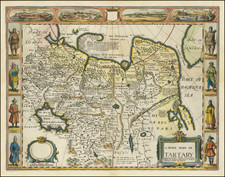
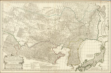
Antique Map of Tartary -- Russian Asia and Northern China, Kazakhstan and Mongolia
Nice example of Speed's map of Tartary, from the first world atlas produced in England.
Speed's map includes a decorative carte à figures. Side panels depict costume figures, while above are vignettes of the cities of Astrakhan, Samarkand and Cambalu, with an illustration of a "house in Nova Zembla". The Great Wall of China is clearly seen, and the interior is heavily annotated. Included in the four views at top is a view of Nova Zembla, the winter quarters of Barents, the Dutch explorer who searched for a northern passage between Russia and America. English text on verso provides a 17th Century description of the region.
John Speed (1551 or '52 - 28 July 1629) was the best known English mapmaker of the Stuart period. Speed came to mapmaking late in life, producing his first maps in the 1590s and entering the trade in earnest when he was almost 60 years old.
John Speed's fame, which continues to this day, lies with two atlases, The Theatre of the Empire of Great Britaine (first published 1612), and the Prospect of the Most Famous Parts of the World (1627). While The Theatre ... started as solely a county atlas, it grew into an impressive world atlas with the inclusion of the Prospect in 1627. The plates for the atlas passed through many hands in the 17th century, and the book finally reached its apotheosis in 1676 when it was published by Thomas Bassett and Richard Chiswell, with a number of important maps added for the first time.

![(Mount St. Elias and Mt Fairweather to Cape Decision, Stika, Juneau and Prince Frederick Sound) Cote Nord-Ouest De L'Amerique Reconnue Par Cape. Vancouver Ve. Partie [Northwest Coast of America as recognized by Captain Vancouver, 5th Part]](https://storage.googleapis.com/raremaps/img/small/88128.jpg)