


|
||

|

|
|

|
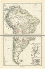
A nice example of this antique engraved sea chart of the western coastlines of South and Central America, published by Louis Renard.
The map covers the Pacific Coast from Xalisco, Mexico, to Puerta Bairres and Rio Cachapool in Chile, covering over two-thirds of the Chilean Coast. In the Caribbean, all of the Yucatan and parts of Cuba and Hispaniola are shown, along with all of Jamaica and the Caymans. Nice detail throughout Central America. Columbia is shown in its entirety, along with a small piece of Venezuela. Includes well over 100 place names in classic Portolano style, along with gorgeous allegorical cartouche, eight sailing ships, and two compass roses.
This marvelous sea chart was first produced by Frederick De Wit in 1675 and later issued in the 18th century by Renard (1715) and Ottens (1745).
![The West India Islands, and Central America [with] Jamaica](https://storage.googleapis.com/raremaps/img/small/78675.jpg)
![(Mexican-Aztec Paintings) Facsimile, page 19 of an original [Mex]ican painting of Sir Thomas Bodley's collection [in the Bod]leian Library, Oxford, [Aglio's] Antiquities, vol. 1](https://storage.googleapis.com/raremaps/img/small/102328.jpg)
