|
||

|

|
|

|
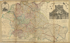
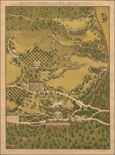
The Most Important Map of 17th Century Bern
Highly important map of the old Bern region, prior to the revolt of Vaud in the early 18th Century, created by Bernese painter, architect and mapmaker Joseph Plepp.
Engraved in Bern, Plepp's maps is drawn largely from the 18 sheet wall map of Thomas Schoepf, published in 1577-1578. However, Plepp has significantly refined and improved Schoepf's work in several areas and added an original view of the City of Bern from the South.
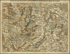
The map is oriented with south at the top - placing Geneva in the upper-right corner, which was then part of Bern, prior to the 1723 revolt led by Major Abraham Davel, which led to the independence of the French speaking Vaud region from the German speaking Bern region.
Zug is in the upper-left corner, just under the scale of miles, with Lucerne seemingly being covered by the scale. Bern, the focus of the map, is just to the left of center. A bird's-eye view of the city is inset in the lower-right corner. The whole is surrounded by a border of coats of arms.
Rarity
The map is very rare. We have been unable to locate any examples coming to market at auction or in dealer catalogs in the past 50 years.
OCLC locates several examples in Swiss and German Libraries.
Joseph Plepp was a Swiss painter, architect and master craftsman and cartographer from Bern.
Joseph Plepp was born in 1595 in Bern as the son of the glass painter Hans Jakob Plepp and Salome Heintz. Plepp worked briefly in Stuttgart as an artist, with one of his earliet works still surviving in the Stuttgart, Württembergisches Landesmuseum.
By 1622, Plepp was back in Bern,where he worked on the construction of the Bernese bailiff's castle, contributing the facade paintings and inside the Landvögte coat of arms. In 1624 he helped the fortress builder Valentin Friderich,with drawings for plans of the cities and castles Lenzburg and Aarburg. His view of Lenzburg (pen, watercolor) created in this context is one of the most beautiful of its time in southwest Germany. Plepp created engraved views of Lenzburg, Aarburg and Nyon, which Merian used as models for the views of his Topographia Helvetiae (1642).
His first map dates from 1623. It is an oil painted map of the city of Bern and the Bremgarten Forest, which is in the Bern Historical Museum. In 1628 he made a bird's eye view of the city of Lenzburg ( State Archives of the Canton of Bern ) and in 1632 a small map of the Tessenberg Marches between Bern and the Duchy of Basel, was added in 1632 (State Archives of the Canton of Bern / City Archives Biel). The templates for the Topographia Helvetiae by Matthäus Merian, first printed in 1642 The published views of Aarburg , Lenzburg, Grindelwald Glacier and the now so famous view of the city of Bern are all works by Joseph Plepp.
During his time as the city planner for Bern, Plepp gave the Käfigturm its current appearance. He also brought the system of the Herrengassbrunnen up to date and connected it to the drinking water pipeline at that time.
The most important cartographic work of Plepp is the copper engraved map of the Old Bernese national territory from 1638. The map based on the 18-sheet map by Thomas Schöpf from 1578. The Plepps map is by far the most faithful follow-up map from Schöpf . With the exception of the mountains and forests, it is a remarkably faithful reduction, with about 90% of the placenames retained. The most noticeable change in content through Plepp was the very precise depiction of the Aare loops below Bern, as well as the new name Nüw Brück, the new bridge near Bern.
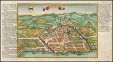
At the bottom right, Plepp has added a southern view of the city of Bern that he probably created himself.
The Plepps map is considered to be the best, most accurate and most correct single-sheet map of the old state of Bern. Copies can be found in the State Archives of the Canton of Bern, the Bern Central Library , the Bern Historical Museum, the Zurich Central Library and the map collection of the Federal Office of Topography.
![[Course of the Rhine River] Corso del Reno Parte Septentrio [and] Corso del Reno Parte Meridionale . . . 1690](https://storage.googleapis.com/raremaps/img/small/73095.jpg)