|
||

|

|
|

|
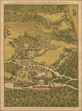
Ski Map of the Davos Area Published in the Mid-1950s
Attractive map of the skiing around Davos, Switzerland. The map shows the many ski runs to be explored in the area, both "downruns" and cross-country runs. An index at the bottom of the map of the map denotes the names of each run alongside the total distance, with several hundred kilometers of runs so-described. A decorative compass rose is included.
The map is attractive, showing pictorial trees as well as skiers enjoying the mountain. The famous resort towns of the area are all named, including the Davos-Platz and Davos-Dorf towns, and the many high-altitude chalets are shown. The verso includes two panoramas of the map includes a full panorama of the area as seen from Weissfluhgipfel. This map was designed by L. Koller.
We trace an example of a 1954 edition of this map digitized by skimaps.org. This map includes a mention of the "Cable Airway Parsenn" that opened in 1955, thus suggesting a slightly later date for this example.
Rarity
Maps of Davos are scarce; this is the second we have had in over 25 years of business. We find no other examples of this map having traded in the antiquarian market.
![[Premier Hotels in Swizterland] Hotels de tout Premier Rang de Suisse](https://storage.googleapis.com/raremaps/img/small/87442.jpg)
![[ Switzerland ] Nouvelle Carte de la Suisse dans laquelle sont Exactement Distingues les Treize Cantons ... Londre Chez W. Faden Charing Cross 1799](https://storage.googleapis.com/raremaps/img/small/102958.jpg)
![[ Pilgrimage of Saint Ursula ] Tabula Alpium et Italiae a Basilea Romam Exhibens Tertiam Partem Itineris S. Ursulae et Sociarum Eius](https://storage.googleapis.com/raremaps/img/small/99739.jpg)