|
||

|

|
|

|
An Important Early Copy of the Lazarus Map of 1528
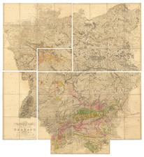
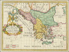
Lazarus’ Map of Hungary (Tabula Hungariae) is one of the most important medieval maps of Europe.
The 1528 Tabula Hungariae
The present map, created from an original drawn by Georg Tannstetter, is the earliest surviving copy of the originalTabula Hungariae, wich was drawm from the manuscript of Lazarus Secretarius, a Hungarian cleric. Tannstetter's map was published by Johannes Cuspinianus and printed in 1528 in Ingolstadt by Petrus Apianus. Tannstetter's map now survives in a single example in the National Library of Hungary.
The map shows the settlements and landmarks of the Kingdom of Hungary in the early 16th century. The southern areas were then occupied by the Ottoman Empire. As the only covered parts outside the border are in the south, it is thought that the purpose of the creation of the map was the preparations for the war against the Ottomans. Some of the settlements shown on the map vanished during the years of Ottoman wars.
The most valued information on the map are the names and descriptions of settlements. There are approximately 1400 geographical names on the map, of which 1270 are names of settlements (365 on the territory of post-Trianon Hungary.) The geographical names were transcribed differently from modern times. For example, today's é was written ee, today's ö was ew. It is also noted that c is sometimes written tz, which is a characteristic of the Old High German orthography. These may be created by contributors, who prepared the work for printing. However, with some other names, Lázár used the pronunciation of Hungarian dialects.
Lazarus' map, Tabula Hungariae, is considered the oldest survived map of Hungary. The original was made around 1515, while a printed version appeared in 1528 in Ingolstadt. It was a much more detailed depiction than anything produced up to that point, illustrating fortifications, settlements, and some historical events. It is an authentic and very valuable document with respect, also, to the situation in the northern part of present day Serbia, just before the Battle of Mohács and the Ottoman expansion after the battle. After its "re-discovery" in 1906, it became the subject of study for a large number of researchers. It also represents a segment of planetary cultural heritage and, as of 2007, has found its place on UNESCO's Memory of the World Register. The original is kept in the Map Collection Hungarica, at the National Széchényi Library in Budapest.
The Tabula Hungariae is also called Lazarus map, because its manuscript was made by a person called Lazarus, who worked under Archbishop Tamás Bakócz (1497-1521) in the chancellery. Katalin Plihál’s studies during the recent years have revealed a person who perfectly fits the known descriptions, Lazarus Tinódy.
The orientation of this map is quite unusual with geographic north rotated to right by about 40 to 45 degrees. The theories for this orientation are generally (1) the map employs a world projection of Ptolemy or that (2) the map has no specific mathematical orientation.
Georg Tannstetter (April 1482 – 26 March 1535), also called Georgius Collimitius, was a humanist teaching at the University of Vienna. \
Tannstetter was a medical doctor, mathematician, astronomer, cartographer, and the personal physician of the emperors Maximilian I and Ferdinand I. He also wrote under the pseudonym of "Lycoripensis". His Latin name "Collimitius" is derived from limes meaning "border" and is a reference to his birth town: "Rain" is a German word for border or boundary.
Born in Rain am Lech in the Duchy of Bavaria, he studied in Ingolstadt. In 1503, he followed a call of Conrad Celtis to the University of Vienna, where he taught mathematics. He soon became a leading figure amongst the humanists in Vienna. In 1510, he became the personal physician of emperor Maximilian I, who would six years later ennoble him with the predicate "von Thanau".
He travelled with his student Joachim Vadian to Buda in 1518. After his earlier work in about 1527 he edited a map of Hungary, today known as Tabula Hungariae, from the manuscript of Lazarus Secretarius, a Hungarian clerk. The map was published by Johannes Cuspinianus, printed 1528 in Ingolstadt by Petrus Apianus. The map now survivese in a single example in the National Library of Hungary. It is generally praised for its details (circa 1300 settlements) and the relative accuracy of the distances between the settlements. It was one of the first regional maps to include a scale but the manuscript was seriously reshaped, so it is difficult to recognize the geography of Hungary.
Tannstetter is also considered a pioneer of the history of science with his work Viri Mathematici, containing biographies of mathematicians at the University of Vienna from the 15th century.
In 1530, he moved to Ferdinand's court at Innsbruck, where he died five years later.