|
||

|

|
|

|
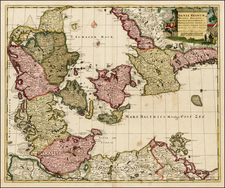
Scarce, Lafreri School Map of the Island of Gotland
Rare and early map of Gotland, engraved by Ferrando Bertelli in Venice in ca. 1560.
The map illustrates the important Swedish island of Gotland, a bustling commercial center in the sixteenth century.
The island is shown with rolling hills, plowed fields, and stands of trees. Several villages hug the coastline. Sea monsters roam nearby, while ships big and small are traversing the waters. A simple, stately cartouche adorns the upper left corner; it is empty save for the name of the map’s maker.
Gotland
Today, Gotland is Sweden’s largest island. The traditional home of the Gutes, the island has had a political relationship with the Swedish crown from at least the late ninth century. It was an important locale for the Vikings and the largest Viking silver treasure, the Spillings Hoard, was found on the island in 1999.
In the Medieval period, Gotland became an important commercial center; Visby, the largest city, was a leading city of the Hanseatic League, one of the most important in the Baltic Sea. Indeed, the city and the rest of the island were administered separately, causing discontent and civil strife.
In 1361, the island was invaded by the Danes, resulting in the death of many of Gotland’s farmers. In 1394, the Victual Brothers took the island, closely followed by the Teutonic Knights, who made it part of their fiefdom. The Grand Master of the Knights sold the island to Queen Margaret of Denmark, Norway, and Sweden in 1409. After passing hands several more times, the island came under Swedish rule, where it has remained since 1645.
Rarity
The map is rare on the market. This is the first example we have ever seen.
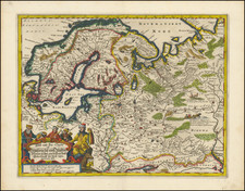
The Lafreri School is a commonly used name for a group of mapmakers, engravers, and publishers who worked in Rome and Venice from ca. 1544 to 1585. The makers, who were loosely connected via business partnerships and collaborations, created maps that were then bound into composite atlases; the maps would be chosen based on the buyer or compiler’s interests. As the maps were initially published as separate-sheets, the style and size of maps included under the umbrella of the “School” differed widely. These differences can also be seen in the surviving Lafreri atlases, which have maps bound in with varying formats including as folded maps, maps with wide, trimmed, or added margins, smaller maps, etc.
The most famous mapmakers of the School included Giacomo Gastaldi and Paolo Forlani, among others. The School’s namesake, Antonio Lafreri, was a map and printseller. His 1572 catalog of his stock, entitled Indice Delle Tavole Moderne Di Geografia Della Maggior Parte Del Mondo, has a similar title to many of the composite atlases and thus his name became associated with the entire output of the larger group.
![[Map of Sweden and Norway] Карта Швеціи и Норвегіи](https://storage.googleapis.com/raremaps/img/small/66784.jpg)