This item has been sold, but you can enter your email address to be notified if another example becomes available.


|
||

|

|
|

|
Stock# 74613
Description
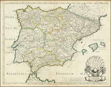
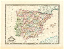
Fine large official Spanish map of the Iberian Peninsula, with an inset of the Canary Islands.
Published by Spain's Ministry of Public Works, the map presents an unusual graphic style which is unique for the period. The map focuses on Spain's roads, rivers, railroads and other infrastructure, including dams and canals.
Of particular note are the circles and semi-circles radiating out from coastal locations and islands, illustrating the line of site for light houses, existing, under construction and projected.
Condition Description
Dissected and laid on linen, with slip case and paste down for Edward Stanford of London
![Les Isles Canaries . . . [With inset map of the Islands of Madeira and Porto-Santo]](https://storage.googleapis.com/raremaps/img/small/70853.jpg)