|
||

|

|
|

|
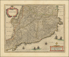
This map, entitled Hispania Antiqua, delineates the ancient territories of what are now Spain and Portugal, capturing the intricate geographical divisions of the Roman provinces Hispania Ulterior and Hispania Citerior, later known as Hispania Tarraconensis. Dating from 1641, this map provides a window into the past, charting the topographical understanding of a region pivotal to the ancient world.
Created by Nicolas Sanson and published by Melchior Tavernier and Pierre Mariette, the map delineates the Iberian Peninsula during Roman times, capturing the vast and varied landscape from the "Oceanus Occidentalis" to the "Mare Internum," known today as the Atlantic Ocean and the Mediterranean Sea, respectively. The attention to detail is apparent in the delineation of coastlines, mountain ranges, rivers, and the locations of ancient settlements.
Historically, the provinces of Hispania Ulterior and Hispania Tarraconensis were significant for their contributions to the Roman Empire, in terms of both military campaigns and resource extraction. The Roman conquest of these regions, beginning in the second century BCE, had a lasting impact on their cultural, linguistic, and architectural development, traces of which are evident to this day.
The scallop cartouche at the bottom of the map is particularly noteworthy. Cartouches in cartography were often used not only for decorative purposes but also to convey information about the map's creation or to honor patrons. The use of the scallop, a symbol commonly associated with pilgrimage, particularly the Camino de Santiago which traverses the map's domain, may suggest a connection to religious journeys, reflecting the cultural significance of the route during the time of the map's creation. The inclusion of such a symbol on a map published in Catholic France in the mid 17th Century indicates the mapmaker's recognition of the Iberian Peninsula's religious and cultural heritage, which was as relevant to the audience of the time as the ancient geographic divisions.
Melchior Tavernier was a member of a large family involved in the publishing trade in Paris in the early years of the seventeenth century. Early in his career, he apparently collaborated with Henricus Hondius, as at least one of his early maps references Tavernier as the seller of a map engraved in Amsterdam, by Hondius. He is probably best known for his publication of a map of the Post Roads of France, which was copied many times until the end of the century. He also issued an atlas under the same title as J. le Clerc's Theatre Geographique, using many of Le Clerc's maps, but incorporating others from different sources. He published composite atlases and also published works for other cartographers, including N. Sanson, N. Tassin, and P. Bertius. He is not to be confused with his nephew of the same name (1594-1665), who also engraved maps for Nicolas Sanson.
Nicholas Sanson (1600-1667) is considered the father of French cartography in its golden age from the mid-seventeenth century to the mid-eighteenth. Over the course of his career he produced over 300 maps; they are known for their clean style and extensive research. Sanson was largely responsible for beginning the shift of cartographic production and excellence from Amsterdam to Paris in the later-seventeenth century.
Sanson was born in Abbeville in Picardy. He made his first map at age twenty, a wall map of ancient Gaul. Upon moving to Paris, he gained the attention of Cardinal Richelieu, who made an introduction of Sanson to King Louis XIII. This led to Sanson's tutoring of the king and the granting of the title ingenieur-geographe du roi.
His success can be chalked up to his geographic and research skills, but also to his partnership with Pierre Mariette. Early in his career, Sanson worked primarily with the publisher Melchior Tavernier. Mariette purchased Tavernier’s business in 1644. Sanson worked with Mariette until 1657, when the latter died. Mariette’s son, also Pierre, helped to publish the Cartes générales de toutes les parties du monde (1658), Sanson' atlas and the first French world atlas.
![[Portugal] Pascaarte vande Zeecusten van Portugal tusschen de Barlenges en de C. de S. Vincente geleghen, vertoonende nae't leven de ware geleghentheijt vande vermaerde Riviere van Lisbona . . .](https://storage.googleapis.com/raremaps/img/small/40065.jpg)
![[ Spain & Portugal ] Hispania nach aller seiner gelegenheit in Bergen, Wåssern, Ståtten, Vólckern, Konigreichen und Inseln.](https://storage.googleapis.com/raremaps/img/small/80549.jpg)