|
||

|

|
|

|
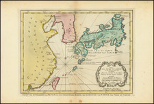
A fine map early map featuring a broadly accurate depiction of Korea, by the French Royal Hydrographer Jacques-Nicolas Bellin.
This attractive map features an early broadly accurate depiction of Korea, based on sources sent to France via China. Unlike earlier representations that showed Korea to be an island or a severely misshaped part of mainland Asia, Bellin's map's presents Korea as a peninsula in a form roughly familiar to the modern eye. Numerous cities and rivers are labeled and the the various provinces are elegantly distinguished by color.
As the ruling Joseon Dynasty had strictly forbidden Westerners from visiting Korea, the peninsula remained an almost complete enigma to Europeans until well into the 18th Century. However, around 1710, China's Kangxi Emperor dispatched agents to Seoul who returned with detailed maps and geographical descriptions of Korea. This intelligence was given to the Jesuit Jean-Baptiste de Regis who created as series of manuscript maps which featured a broadly accurate depictions of Korea. These maps were were published in China as part of the Kangxi Atlas (1718-19).
The leading French cartographer Jean-Baptiste Bourguignon D'Anville (1697-1782) acquired copies of the Kangxi maps, including the maps of Korea and devised his own interpretations, first printed in Jean-Baptiste Du Halde's Description Geographique … de la Chine (Paris, 1735).
Jacques-Nicolas Bellin (1703-1772), the Royal Hydrographer to Louis XV, claimed on the present map to have derived his sources from "an English map" so as to avoid a copyright dispute, when in reality he used the work of his rival D'Anville as his model.
The present edition was published as part of Bellin's Petit Atlas Maritime.
Jacques-Nicolas Bellin (1703-1772) was among the most important mapmakers of the eighteenth century. In 1721, at only the age of 18, he was appointed Hydrographer to the French Navy. In August 1741, he became the first Ingénieur de la Marine of the Dépôt des cartes et plans de la Marine (the French Hydrographic Office) and was named Official Hydrographer of the French King.
During his term as Official Hydrographer, the Dépôt was the one of the most active centers for the production of sea charts and maps in Europe. Their output included a folio-format sea atlas of France, the Neptune Francois. He also produced a number of sea atlases of the world, including the Atlas Maritime and the Hydrographie Francaise. These gained fame and distinction all over Europe and were republished throughout the eighteenth and even in the nineteenth century.
Bellin also produced smaller format maps such as the 1764 Petit Atlas Maritime, containing 580 finely-detailed charts. He also contributed a number of maps for the 15-volume Histoire Generale des Voyages of Antoine François Prévost.
Bellin set a very high standard of workmanship and accuracy, cementing France's leading role in European cartography and geography during this period. Many of his maps were copied by other mapmakers across the continent.
![[ Japan ] Royaume du Iapon. Designe par le Pere Ph. Briet de la Compagnie de Iesus . . .](https://storage.googleapis.com/raremaps/img/small/75238.jpg)
![Asie . . . 1650 [with unusual depiction of the West Coast of North America and the Island of Corey]](https://storage.googleapis.com/raremaps/img/small/102556.jpg)