


|
||

|

|
|

|
Stock# 75238
Description
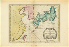
Striking early map of Japan and Korea, published in Paris by Pierre Mariette.
Briet's map follows the Blancus/Moreira model, and looks very similar to the Christophoros Blancus unpublished map of 1617.
The map shows a well-shaped Japan with named provinces, and major cities including Tokyo (Yendo) and Kyoto (Meaco). Kyushu and Shikoku are shown with exaggerated inlets, and the tip of Hokkaido is Terre de Iesso. Korea is described as an island, but is only partially shown.
Condition Description
Trimmed to the neatlines, with new margins added in the style of a Lafreri map. Minor soiling.
Reference
Walters #32, OAG 31; Cortazzi, Isles of Gold #67.
![[The United States in North America | Russian Empire in Europe] [Kita-Amerika-nai Gasshukoku | Yoroppa-nai teikoku Roshia]](https://storage.googleapis.com/raremaps/img/small/55548.jpg)
![[USS Powhatan Carrying the First Japanese Embassy to America.]](https://storage.googleapis.com/raremaps/img/small/55550.jpg)