|
||

|

|
|

|
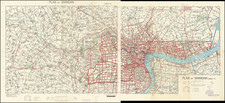
English language tourism map for Taipei City, then re-named Taihoku by the Japanese, during the period of its Japanese occupation between 1895 and the end of World War II.
The map includes an inset of the Vicinity of Taipei, as well as photos of landmarks around the city and one of a "Formosan Girl."
Taihoku / Taipei
Prior to the significant influx of Han Chinese immigrants, the region of Taipei Basin was mainly inhabited by the Ketagalan plains aborigines. The number of Han immigrants gradually increased in the early 18th century under Qing Dynasty rule after the government began permitting development in the area. In 1875, the northern part of the island was incorporated into the new Taipeh Prefecture.
The Qing dynasty of China made Taipeh-fu the temporary capital of the island in 1887 when it was declared a province (Fukien-Taiwan Province). Taipeh was formally made the provincial capital in 1894. Taipei was renamed Taihoku in 1895 when the Empire of Japan annexed Taiwan. Under Japanese rule, the city was administered under Taihoku Prefecture. Taiwan's Japanese rulers embarked on an extensive program of advanced urban planning that featured extensive railroad links. A number of Taipei landmarks and cultural institutions date from this period.
Following the surrender of Japan to the Allies in 1945, effective control of Taiwan was handed to the Republic of China (ROC). After losing mainland China to the Chinese Communist Party in the Chinese Civil War, the ruling Kuomintang relocated the ROC government to Taiwan and declared Taipei the provisional capital of the ROC in December 1949. Taiwan's Kuomintang rulers regarded the city as the capital of Taiwan Province and their control as mandated by General Order No. 1.
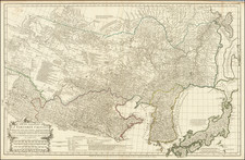
![[ China ] L'Empire De La Chine dresse d'apres les Cartes de l'Atlas Chinois . . . 1751](https://storage.googleapis.com/raremaps/img/small/90831.jpg)