![[ Electors of the Holy Roman Empire ] Ordines Sacri Romani Imp: Ab Ottone III Instituti By Abraham Ortelius](https://storage.googleapis.com/raremaps/img/small/99053.jpg)


|
||

|

|
|

|
Dynamic Plates Depicting the Electors of the Holy Roman Empire
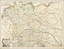
Finely engraved pair of images depicting a group of the Electors of the Holy Roman Empire. These plates were originally engraved by master engraver Antonie Wierix for Gerard de Jode’s atlas, Speculum Orbis Terrae, but later re-issued in Abraham Ortelius’ Parergon, the first historical atlas.
This engraving was first published in 1593 in de Jode’s atlas. The plate was later acquired by Vrients and, from 1603, was included in Ortelius's Theatrum and Parergon.
The engraving depicts the nobles who are entitled to choose Emperors of the Holy Roman Empire. These plates show the highest-ranking officials at the top and the least powerful at the bottom. The emperor is centered at the top of the plate, seated on an elaborate throne, with seven officials surrounding him. On his right are three ecclesiastical electors, and on his right four lay dignitaries. These men are all depicted in long robes, carefully rendered to show the folds and drapes of the fabric. Each carries his own unique item, such as a key or a scroll.
The second rank consists of four dukes and four marquises. Below them stand eight provincial and military earls. The second plate also contains three rows of electors, with the first being four dignitaries and four soldiers (identifiable by their plumed helmets). The next row shows four freemen and four city representatives, while the bottom row portrays four farmers and four village representatives. Each man is dressed in ornate clothing appropriate to his station.
Each man has a shield with his coat of arms, which helps to identify him along with his name below. Of particular note is the Emperor’s coat of arms, the double-headed Imperial eagle, which was the symbol of the Holy Roman Empire. This eagle was likely derived from the ancient Roman aquila or eagle standard carried by Roman legions, making it a great expression of power.
It should be noted that the double-headed Imperial eagle only came into use in the fourteenth century (earlier coats of arms used a single-headed eagle). This indicates that although the text at the bottom of the plate discusses events from 974 AD, the Emperor and electors depicted are more contemporary to the plate’s creation in the 1500s.
The Crowning of Otto III
According to the text at the bottom of the second plate, when the Emperor Otto II died, the crown of the Holy Roman Empire passed to his son Otto III. Otto III appointed his cousin to be Pope, and the newly appointed Pope Gregorius V crowned Otto III with support from the German electors. However, when the new Emperor visited Rome, Pope Iohannes expelled the new Pope Gregorius V from the city, enraging the Emperor. Otto III took Rome by force and implemented a new system that would give electoral power to appoint the Emperor to seven German lords.
The text also notes that Otto III, 28 years old at the time, was known as an incredibly acute man. The writer also concedes that, though the conflict is said to have happened in the year 974, there are differing opinions on the accuracy of this date.
In fact, the accuracy of this entire story is somewhat unclear, as Otto III was only three years old when he inherited the crown and did not even live to the age of 28. In addition, the conflict is now known to have occurred in the 990s. Some aspects are correct, however, as the new Emperor did appoint his cousin as Pope Gregorius V, and he did quell a Roman revolt shortly thereafter. Otto III was also known as an intelligent and educated ruler. The text on this plate is likely as accurate as was known at the time of engraving.
Parergon
Although best known for his world atlas, the Theatrum Orbis Terrarum, the Parergon was a project of personal interest and the work that Ortelius himself considered his greatest achievement. He had a deep curiosity about classical antiquity which spurred him to create the Parergon maps, and the amount of time and detail he put into each map is clearly evident. Ortelius hand drew each map of the Parergon, which required considerable skill and knowledge of the area’s history and geography. It is considered the first historical atlas.
Parergon means supplementary and, accordingly, the first three Parergon maps were published as supplements to the 1579 edition of the Theatrum, which had already been in print for nine years. Over time, successive editions of the Theatrum were supplemented with more Parergon maps, and there are 55 known plates overall. The Parergon was also published as its own atlas separate from the Theatrum on two occasions, once in 1595 and again in 1624.
The Parergon was highly successful both as a supplement to the Theatrum and on its own. It was variously translated into French, German, Italian, and English and regularly printed until 1612. Further editions were more sporadic but still popular, such as the 1624 edition which was published twenty-six years after Ortelius’ death in 1598.
Overall, the detail present in the plates is a testament to de Jode’s skill as much as his dedication to accurate historical representation. Its re-issuing in Ortelius’ atlas has given it the acclaim and visibility that it could not receive in a less famous atlas. These plates would be a valuable addition to collections of Gerard de Jode’s work, Ortelius’ Parergon, or historical work related to the Holy Roman Empire.
![[PT Barnum's American Museum] Barnum's Amerikaansch Museum te New York.](https://storage.googleapis.com/raremaps/img/small/86078.jpg)