|
||

|

|
|

|
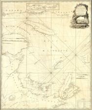
The First Illustration of the First Recorded House in Canada.
Exceptionally rare and important engraved map from the 1613 book by Samuel de Champlain, Les Voyages du Sieur de Champlain Xaintongeois.
The map illustrates the juncture of the Saguenay and Saint Lawrence Rivers, as surveyed by Champlain at the beginning of the 17th century.
This was page 172 from Les Voyages... and was one of 13 copper plate maps and charts from the book.
Burden (180) comments on the map:
Part of a group of sea charts that were the first of North America. When Champlain visited Tadoussac it was already a trading post of three years' standing. The first recorded house in Canada is here identified, abitasion du Cappn chauuain de l'an 1600. It is located at the mouth of the Saguenay River where it flows into the St. Lawrence River.
Champlain's 1613 Book: Les Voyages du Sieur de Champlain Xaintongeois
Generally regarded as one of the fundamental works on the discovery and exploration of America, "the volume deals very fully with the natural history of the country, its soil and products, and is especially minute in its description of the manners, customs, and habits of the Indians. In this edition the text is much fuller than in that of 1632..." (Church)
Champlain's book made manifest the mapping of the "first truly scientific cartographer of North America". The scientific exploration and mapping of New France began with the work of Samuel de Champlain, whose exceedingly rare depictions of the American Northeast are the most important and accurate 17th-century maps of the region. Champlain based his maps on his own discoveries in New France and New England in the early 1600s and published them to accompany the accounts of his voyages. His awareness of the recent English discoveries by Hudson and others to the North also allowed him to integrate, for the first time, the entire body of exploration in the region up to 1611 on a single printed map.
Champlain's explorations were the first 17th century travels to have a major effect on contemporary cartography, and they defined the direction of French explorations in the New World for the rest of the century. Champlain's Carte Geographique de la Nouvelle Franse is the explorer's first significant map of the vast area. Champlain penetrated farther into the interior than any previous explorer, and the geographical discoveries that can be credited to him -- and that are recorded for the first time on the large map included in this volume -- are almost too numerous to name.
Champlain's maps are also credited with initiating the mapping of the Great Lakes, and they constitute the earliest accurate delineations of the New England coastline, preceding John Smith's map by several years. Champlain had explored this region in several voyages he made as official geographer and mapmaker to New France, and his large map reaches to 40 degrees, beyond Cape Cod and Long Island, although in fact, Champlain did not travel further south than the Cape Cod and Martha's Vineyard region in his travels of 1605 and 1606 (the farthest south Champlain reached prior to publication of the maps). These discoveries preceded the important voyage by Captain John Smith and Adrian Block.
This is the second book published by Champlain, following his first publication covering his voyage of 1603, which was entitled: Des sauvages, ou Voyage de Samuel Champlain, de Brouage, fait en la France nouvelle l'an mil six cens trois. That book, which was published in Paris in 1603, is considered completely unobtainable for collectors.

![[Lake Champlain and environs] Carte de la Riviere de Richelieu et du Lac Champlain](https://storage.googleapis.com/raremaps/img/small/91308.jpg)