


|
||

|

|
|

|
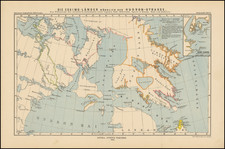
The Most Detailed Chart of the St. Lawrence River to Date
Fine example of Thomas Wright’s definitive chart of the St. Lawrence River, based on his careful survey of the region.
Thomas Wright, patriarch of a family of surveyors, originally worked with William Gerard de Brahm in the Southern Colonies, before being appointed deputy surveyor to Samuel Holland in the Northern District. He would go on to become one of the foremost experts on the geography of eastern Canada, who continued to improve on the work of Holland’s General Survey of North America. By 1773, he would rise to the level of Surveyor General of the St. John's Colony and was briefly taken prisoner by the Colonial Army in 1775, but was later ordered released by General George Washington.
Wright's chart shows the St. Lawrence River as it empties into the Gulf of St. Lawrence around Anticosti. It includes the coast of Labrador, in the north, to Cape Breton and Nova Scotia in the south. Near the center of the chart are the Magdalen Islands.
Shorelines and bays include sounding depths and variation measurements. Profile views of the shore are tucked inland near Chaleur Bay and are off the coast of Cape Breton. In the lower right is a table with coordinates that have been determined by astronomical observations. At the top is an inset of the Mingan and Esquimaux Islands. At the lower left is a depth table with notes on the tides. All of these additions would be useful to a navigator sailing in the area.
The cartouche in the upper right shows a small homestead through a natural archway. A ship is moored in a nearby harbor where fishermen spread their nets. In the foreground are walruses resting. The entire scene is a pastoral dream of what life in British Canada could be.
Wright served as a deputy surveyor under Samuel Holland during the first large-scale survey of British North America. He was integral to the surveys of New England and the Gulf of St. Lawrence, contributing to Holland’s wall map of New Hampshire.
Wright privately published three charts concerning the St. Lawrence: “A new Chart of the Gulf and River of Saint Lawrence to the Southern boundary of Lower Canada” (ca. 1785), “A New Chart of the Gulf of St. Lawrence” (1790), and “A New Geographical and Nautical Chart of the Gulf and River St. Lawrence” (1807). This chart, the 1790 effort, is meticulously detailed and shows the considerable skill that was required to accurately and carefully depict such a crucial area.
Wright and the Survey of the Gulf of St. Lawrence
Wright continued to improve on his survey of the St. Lawrence in the later-eighteenth century, adding details and the latest information concerning tides and navigational obstructions. The initial survey work was completed, however, in the 1760s, as part of Holland’s monumental surveys of Canada and New England. The General Survey of North America was approved by the Privy Council on February 10, 1764 and was to be organized by the Lords of Trade and the Admiralty.
The surveying teams were tasked with creating high-quality, high-resolution maps and charts that were precisely keyed to latitude and longitude. They also had to provide cadastral surveys for Cape Breton and St. John’s Island, projects to which Wright contributed heavily.
Wright was one of several deputy surveyors to Holland. They sailed together for North America on the Canceaux, under Lieutenant Henry Mowat, reaching the Newfoundland Banks on June 27, 1764 and then heading for Quebec. After a quick stay there, Holland and his men sailed to St. John’s Island, where Wright would later serve for decades as the Surveyor General.
At first, Holland thought he would survey the island by land. He sent out another deputy surveyor, Haldimand, but the party was soon stranded with no provisions. Wright was sent out to find Haldimand, but his groups also soon fell into distress. They were rescued by the ship’s schooner, which had nearly sunk itself, and Holland decided to proceed with the initial survey from small boats instead.
Holland, Wright, their men and the ship’s crew wintered at St. John’s. Taking advantage of the frozen waterways, the surveyors circled the island in the coldest months of late 1764 and the first part of 1765. Wright was responsible for charting the westernmost parts of the island. By late summer, all parties had finished their work.
This process was repeated for Cape Breton in 1765-6, with Wright again surveying the western portion of the island. He was then sent to Anticosti, where he led the survey and wrote a description of his work, which was published in 1768, while he was on leave in England.
He returned in mid-1769. While in London, Wright met with Astronomer Royal Nevil Maskelyne and they discussed the best way to observe the Transit of Venus, the most anticipated astronomical event of the century. While traveling to rejoin Holland, Wright performed observations of the Transit at the Île aux Coudres in the St. Lawrence. He saw the internal movement of Venus across the Sun, but missed the moment of external contact. Both he and Holland submitted their findings to the Royal Society in London. Of Wright’s work, Maskelyne wrote, “His observations seem to me to be made with proper care & knowledge of the subject, & likely to be useful, in conjunction with those made by Captn. Holland & the many other observers dispersed in various places, in determining the grand problem of the Sun’s distance from the Earth” (as quoted in Hornsby, 64).
After more than five years, Holland declared the survey of the Gulf finished in 1770. He took his deputy surveyors, including Wright, to their next challenge, the survey of New England.
Rarity
This important chart is rare. We locate examples in the National Maritime Museum (Greenwich), the Clements Library at the University of Michigan, and the Biblioteca Nacional (Madrid), and four examples at the British Library.
Thomas Wright was one of the foremost surveyors of the colonial period, serving across British North America. He was also an astronomer, judge, and a government official. Brought up in London, he studied at Christ’s Hospital, where he learned drawing and mathematics.
Wright ventured to North America for the first time in 1758. There, he continued his training as a surveyor, working with William Gerard de Brahm, then Surveyor General of Georgia. In 1763 he was appointed a deputy surveyor to Captain Samuel Holland, Surveyor General of the Northern District of North America. Wright was crucial to the surveys of St. John’s, Cape Breton, and the St. Lawrence River.
In 1767, Wright returned to England to ferry plans back to London. He sailed across the Atlantic again in 1769, having been assigned to observe the Transit of Venus from Quebec. He rejoined the survey of the Northern District, working with Holland in the Bay of Fundy and in New England.
Unlike many of Holland’s deputies, Wright was a civilian. He tried to secure a military commission, but was unsuccessful. Opportunity knocked when St. John’s Island was made a separate colony from neighboring Nova Scotia. Wright impressed incoming Governor Walter Patterson, who made Wright a member of the Council. An appointment as Surveyor General of the colony followed in 1773, although Wright continued to work with Holland as well. Due to the organization of landowners on St. John’s Island, meaning there was little Crown land to manage, Wright found himself with spare time to serve as a Supreme Court judge. His prominence meant that was taken prisoner at the beginning of the American Revolution, in 1775, when American privateers raided Charlottetown. He and a fellow official, Philipps Callbeck, were ordered to be released by General George Washington.
That same political prominence meant that Wright was also a target in colonial disputes. When St. John’s became a separate colony, it was supposed to support itself based on the collection of quitrents, or small annual fees paid by landowners. However, proprietors of the colony proved unwilling to pay, landing the colony in arrears. By 1781, Governor Patterson began to single out townships for their debts and selling them at auction.
These unpopular actions of Patterson’s harmed Wright’s career. He was suspended from both the Council and his position as Surveyor General in 1787. He was quickly reinstated, but the damage had been done. The landowners brought charges against Patterson and the Council; it was put before the British Privy Council in 1789. Wright defended himself at the trial and received a drubbing. He lost his Council position permanently but was allowed to maintain his role as Surveyor General due to the needs of his large family. Wright was not as active in local politics following the trial, although a Thomas Wright, either Wright himself or his son, served in the House of Assembly from 1797 to 1802.
Although several of Wright’s sons also worked as surveyors, the family still struggled. This was due in large part to the difficulties Wright had in obtaining his salary from the British Crown across his career. In St. John’s, his salary was to be paid by the quitrents, which were not reliably submitted. Once that system was abandoned, Wright complained that his salary had been unfairly reduced. The issue was not resolved until 1806.
Wright carried on with his work, however. He was a prominent member of the boundary commission established in 1796 to designate the border between the District of Maine and New Brunswick. As astronomer for the British delegation, Wright was returning to an area he had already surveyed over twenty years before. With his American counterpart, Wright took excellent observations, pinpointing the rivers in question. In the summer of 1797, Wright and Robert Pagan found the remains of early buildings built by Champlain and Du Gua de Monts in the early seventeenth century, proving which of the St. Croix Rivers was the original and which should therefore be used as the boundary.
He also published his findings. His Description of the island of Anticosti appeared in 1768. His correspondence with Astronomer Royal Nevil Maskelyne resulted in an article on the satellite of Jupiter, published in the Philosophical Transactions of the Royal Society in 1774.
Wright died in 1812 after fifty years of active service. He had surveyed from Georgia to the Maritime Provinces. While not as famous as Holland and Des Barres, he is still an important figure in the surveying of British North America, especially of the St. Lawrence River Basin. Two of Wright's sons and a grandson followed him as Surveyors General of St. John's Island, meaning a Wright for in the position for the first eighty years of the colony's existence.
![[Boston / Anapolis Royal / Plaisance] Plans des Isles, Rades, et Ports de plusieurs Lieuxde l'Amerique Tires de la Carte Angloises de Mr. Popple publiee en 1733 a Londres en Vingt Feuilles.](https://storage.googleapis.com/raremaps/img/small/85117mb.jpg)
![[Inhabitants of New France] Einwohner von neu Frankreich](https://storage.googleapis.com/raremaps/img/small/94772.jpg)