


|
||

|

|
|

|
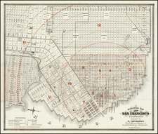
Rare, possibly unrecorded issue of this early map of San Francisco, the notable "Red Line" map showing the areas to be expanded into the bay, then under water.
The present map is similar to the so-called "Official Map" by Eddy.
Above the title of the present map is the ink signature of S.W. Holladay. Holladay was the defendant in lawsuit regarding his occupation of Lafayette Park in San Francisco, which wound its way up to the U.S. Supreme Court over what was apparently several decades.
The map later re-issued with a different title, Copy of the Official Map of San Francisco, with the manuscript red line printed in black.
Describing the later reprinting, Warren Heckrotte notes:
In 1849, William M. Eddy resurveyed the city and enlarged O'Farrell's map. In 1851, he submitted a revised map that further extended the street plan . . . . The inner . . . line marks the actual shore line; Yerba Buena Cove is immediately recognizable - Montgomery Street fronts the water line. The outer . . . line marks the waterfront out to which the city would grow - the lots in between these two lines were under water and would await filling to be built upon (These two black lines are red on the original. This map is known as the Red Line map). . . . A striking feature of this layout of the city is that the grid completely ignores the topography, a pattern which persisted with the growth of the city. Much of the area shown on the map was sparsely populated at this time and some streets were not yet laid out on the ground."
Rarity
OCLC locates no copies of this map, but notes 3 copies with the same title, but dated January 15, 1852. (California Historical Society, Huntington Library, and Yale).
![[ Sunol, California ] Res. & Farm of Duerr & Nusbaumer, Sunol., & T.F. Bachelder's Ranch, Alameda County, California](https://storage.googleapis.com/raremaps/img/small/102044.jpg)
![[ Washington Township / Murray Township ] Res. & Stock of J.T. Walker, Washington on Corners & Residence and Farm of Christian Knittel, Murray Tp, Alameda County, California](https://storage.googleapis.com/raremaps/img/small/102042.jpg)
![[San Francisco] View of the Exposition Site As Seen From San Francisco Bay](https://storage.googleapis.com/raremaps/img/small/64867.jpg)