|
||

|

|
|

|
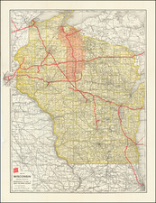
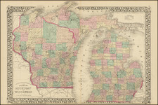
Unrecorded early Wisconsin Central Railway Map
Rare Map of a portion of Wisconsin and extending Minneapolis, published for the Wisconsin Central Railway.
The map shows early Roads, Indian Reservations, Cities, Towns, Counties, Lakes, Rivers, Railways, and Rail Lines Under Construction.
While the map is undated, it was likely made in 1906 or 1907, as the line reached Ladysmith in 1906, but did not reach Superior until 1908. The present map shows the line between the two cities as under construction.
The map was apparently intended to appeal to recreational and vacation travellers, given the reference to hunting and lakes.
Wisconsin Central Railway
The Wisconsin Central Railway was created in 1897 when the Wisconsin Central Railroad (1871–99) was reorganized from bankruptcy.
After a proposed merger with Northern Pacific Railway fell through in 1908, the Wisconsin Central was leased by the Minneapolis, St. Paul and Sault Ste. Marie Railroad, commonly known as the Soo Line, in 1909. The controlling interest in the Soo Line, along with Wisconsin Central, was held by the Canadian Pacific Railway. Wisconsin Central entered receivership in 1932, declared bankruptcy in 1944, and finally re-emerged from administration in 1954 as the Wisconsin Central Railroad. It was entirely merged into the new Soo Line Railroad in 1961.
Rarity
The map is apparently unrecorded. No examples located in OCLC or elsewhere.