|
||

|

|
|

|
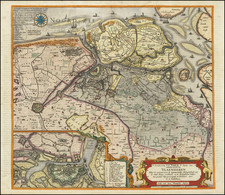
Herman Moll's regional map of Belgium and Luxembourg, showing its political affiliations during the time of its creation.
The map provides an expansive and finely detailed presentation of the region, extending from the North Sea coast of Belgium to the heartland of the Netherlands. The map encompasses Flanders, or what was known as the Austrian Netherlands during the 18th century, along Luxembourg and the Bishopric of Liege.
Moll's map is exceptionally detailed. It boasts an intricate mesh of towns, roads, rivers, and other geographical features, bringing to life the vibrant tapestry of this historically significant region. Cities and towns are meticulously marked with minuscule icons, each significant in their representation. Major cities like Antwerp, Bruges, and Ghent, along with numerous smaller towns, are discernible, hinting at the region's urban richness.
Herman Moll (c. 1654-1732) was one of the most important London mapmakers in the first half of the eighteenth century. Moll was probably born in Bremen, Germany, around 1654. He moved to London to escape the Scanian Wars. His earliest work was as an engraver for Moses Pitt on the production of the English Atlas, a failed work which landed Pitt in debtor's prison. Moll also engraved for Sir Jonas Moore, Grenville Collins, John Adair, and the Seller & Price firm. He published his first original maps in the early 1680s and had set up his own shop by the 1690s.
Moll's work quickly helped him become a member of a group which congregated at Jonathan's Coffee House at Number 20 Exchange Alley, Cornhill, where speculators met to trade stock. Moll's circle included the scientist Robert Hooke, the archaeologist William Stuckley, the authors Jonathan Swift and Daniel Defoe, and the intellectually-gifted pirates William Dampier, Woodes Rogers and William Hacke. From these contacts, Moll gained a great deal of privileged information that was included in his maps.
Over the course of his career, he published dozens of geographies, atlases, and histories, not to mention numerous sheet maps. His most famous works are Atlas Geographus, a monthly magazine that ran from 1708 to 1717, and The World Described (1715-54). He also frequently made maps for books, including those of Dampier’s publications and Swift’s Gulliver’s Travels. Moll died in 1732. It is likely that his plates passed to another contemporary, Thomas Bowles, after this death.
![[France, Belgium, Switzerland and Gemany]](https://storage.googleapis.com/raremaps/img/small/75179.jpg)
![[Nine city views from the Low Countries, including Grevelingen, Ghent, Aat, Winochs-Bergen, Arras, Bethune, and Ypres]](https://storage.googleapis.com/raremaps/img/small/79603.jpg)