


|
||

|

|
|

|
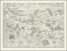
Striking Gastaldi Map of West Africa, Included in a Significant Travel Collection
Finely-wrought early map of West Africa, compiled by Giacomo Gastaldi for Giovanni Battista Ramusio's Navigationi et Viaggi. This is an example of the first state, which was first published in 1556.
The map shows the western portion of the African continent from just north of the Tropic of Cancer to the island of St. Thomas in the Gulf of Guinea, where the equator intersects the landmass. The deep interior is filled with mountains and trees, although Europeans actually knew very little of this area when the map was made. There is also a menagerie of animals wandering the countryside, including lions, elephants, monkeys and camels.
Closer to the shores of the African coast, where Europeans conducted their trade in posts called castles, is much rich imagery. One of these castles, the earliest on the Gulf of Guinea, Elmina, features prominently on this map. The castle survives today and is the oldest European building in existence south of the Sahara. Established in 1482, the castle was originally a trading factory; later, it was used to hold enslaved people bound for the Middle Passage and then plantations in the Americas.
Even more imagery dots the coast. For example, a lion stares at a burning mound in the west, while a pair of Africans approach a group wearing plumed hats and holding spears. Behind them is a hut in an enclosure where people genuflect to a leader. East of Elmina are children playing with monkeys, and a group of hunters conversing.
Out to sea, four canoes with pairs of rowers are near shore. There are two European ships. The larger is displaying the five dots of the Portuguese Crown’s coat of arms. It is bound for Elmina, according to a note nearby. Farther west is another vessel, this one with the three fleur-de-lis of the French. Amongst these man-made vessels are many sea monsters, some with remarkably mammalian heads.
States of this map
This map is known in two states. One appeared in volume three of Ramusio’s travel collection, first published in 1556. The second state, of the 1606 edition, is recognizable by evidence of woodworm damage to the printing block and the pagination numbers “370” and “371.”
Ramusio’s Navigationi et Viaggi
Ramusio, a Venetian civil servant, spent decades gathering images, accounts, and sources for a massive collection of travels and voyages. He wanted to update the geographic knowledge of antiquity, which was being challenged by European interactions with the Americas, Africa, and Asia. He especially wanted his work to be useful to mapmakers in updating their representations of the known world.
One of the larger printing projects of the sixteenth century, the collection eventually appeared in three volumes. They were published by Tommaso Giunti in Venice and only in a later edition, in 1563, was the author revealed to be Ramusio. The first volume was published in 1550 and held information about Africa, India, and the East Indies. The second was published in 1559 and discussed Russia, the Middle East, and Central Asia. The third volume, published before the second in 1556, held information about the Americas.
The second volume was delayed because of a large fire in Ramusio’s workshop in 1557; the flames ruined the volume’s woodblocks, forcing the second edition to be published two years later and with no maps. The maps that were included in the other volumes were most likely the work of Giacomo Gastaldi, who tutored Ramusio’s son. While the first volume had three maps and plans, and the second none due to the fire, the third volume had nine maps of the Americas, Africa, and the East Indies.
The work was an important milestone in publishing and each edition was reprinted several times: volume I in 1550, 1554 (with additions), 1563 (with an additional leaf mentioning Ramusio as author), 1588, 1606, and 1613; volume II in 1559, 1574 (with additions), 1583 (further additions), and 1606; and volume III in 1556, 1565 and 1606 (with additions). Only once, in 1606, were all three volumes reprinted in the same year.
Giovanni Battista Ramusio (1485-1557) was an Italian geographer who worked within the Venetian Empire. His father had been a magistrate and he himself served as a civil servant to Venice. He served throughout Europe, allowing him to build up a network of informants and a collection of travel materials. He compiled this information into his enduring masterpiece, Navigationi et Viaggi, in 1550 (first volume) and 1556 (third volume). The second volume appeared after his death in 1559, as the original manuscript had been destroyed by a fire.
Giacomo Gastaldi (1500-1566) is considered the foremost Italian cartographer of the sixteenth century, alongside Paolo Forlani. His skills of compilation are comparable to those of Mercator and Ortelius, yet much less is known of his life than of his two contemporaries. Gastaldi was born in Villafranca, Piedmont, but had established himself in Venice by 1539. He originally worked as an engineer, but turned to mapmaking from the 1540s onward.
It was in Venice where he made his reputation as an engraver, geographer, and cosmographer; for example, he was asked to fresco maps of Asia and Africa in the Palace of the Doge, or the Council of Ten, Venice’s governmental body. He also frequently consulted on projects for the Savi sopra la Laguna, drawing maps for this body which oversaw the regulation of fresh and salt water around Venice.
His contemporaries also recognized his skill, as he was named cosmographer to the Republic of Venice, was a member of the Accademia Veneziana, and was a major source for other geographers and mapmakers including Camocio, Bertelli, Cock, Luchini, and Ortelius. He even had his own distinct style of copper engraving that made him a pioneer in his day and makes his works iconic today.
Gastaldi enjoyed an especially productive relationship with Giovanni Battista Ramusio, Secretary of the Venetian Senate, who used Gastaldi's maps for his famous travel account collection, Navigationi et Viaggi. Gastaldi also tutored Ramusio's son in cosmography.

![[Senegal / Safaris / Railroads] Chemins de Fer du Senegal](https://storage.googleapis.com/raremaps/img/small/88789.jpg)
![[Democratic Republic of the Congo] Congo Belge](https://storage.googleapis.com/raremaps/img/small/77991.jpg)