|
||

|

|
|

|
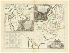
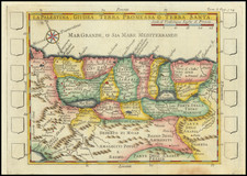
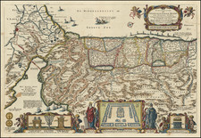
This map, titled Situs Terrae Promissionis S.S. Bibliorum intelligentiam exacte aperiens per Chr. Adrichom, created by Henricus Hondius and published in Amsterdam circa 1645, represents an early rendition of the Holy Land based on the influential work of Christian Van Adrichom. It features Latin inscriptions and illustrates a "land of torrents, waters, fountains, and valleys, and of wheat, barley, vines, figs, and pomegranates; a land of olive oil and honey."
During the 17th century, the mapping of the Holy Land was a subject of great interest, motivated by religious curiosity, scholarly pursuits, and the desire for understanding Biblical geography. Christian Van Adrichom, a theologian, was a key figure in this endeavor, and his work became the foundation for subsequent representations, including that of Hondius. This map, portraying the lands as described in the Scriptures, served not only as a geographical guide but also as an embodiment of religious belief and scholarly interpretation.
Hondius' rendition of the map is notable for its wonderful imagery, realized by the engravers Everardus Sim. Hamersveldt and Salomon Rogeri. It is a work of both artistic and historical significance, capturing the topographical features of the region along with symbolic and Biblical references. The Latin text that accompanies the map adds to its scholarly and theological resonance, offering a textual dimension to the visual portrayal.
As a historical artifact, Situs Terrae Promissionis S.S. Bibliorum intelligentiam exacte aperiens per Chr. Adrichom encapsulates a particular moment in the history of cartography, reflecting the confluence of religious, intellectual, and artistic trends of the time. It stands not only as a geographical representation but also as an expression of a worldview, a testament to the intricate relationship between faith, scholarship, and the exploration of the world.
Henricus Hondius (1597-1651) was a Dutch engraver and mapmaker, a member of a prominent cartographic family. His father, Jodocus Hondius, was also an engraver and geographer. While working with his father, Henricus was instrumental in the expansion and republishing of Mercator’s atlas, first published in 1595 and republished by Hondius in 1606.
Upon his father’s death in 1612, Henricus and his brother, Jodocus the Younger, took over the business. He set up his own shop in 1621, where he continued to release new editions of the Mercator atlas. Later, he partnered with his brother-in-law, Jan Janssonius, in continuing to expand and publish Mercator’s atlas, which would become known as the Mercator-Hondius-Janssonius atlas. Born and based in Amsterdam, he died there in 1651.