


|
||

|

|
|

|
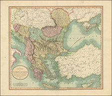
Map of Turkey, Greece, the Holy Land and the Eastern Mediterranean, illustrating the eastern portion of the Roman Empire.
The map depicts the Roman Empire based upon the writings of Eusebius, Socrates, and Euagrius.
One of the key figures in the early history of the Roman Empire was Eusebius, a historian and bishop who lived in the 4th century CE. Eusebius is best known for his historical works, including a chronicle of the Roman Empire and a history of the Church. In these works, Eusebius wrote about the early Christian Church and its relationship with the Roman Empire, as well as the lives of various emperors and other important figures.
Euagrius was a historian who lived in the 5th century CE and is known for his work "Ecclesiastical History," which covers the period from the 4th to the 6th century CE. Euagrius wrote about the spread of Christianity, the conflicts between various factions within the Church, and the lives of various bishops and other religious figures.
The map appeared in Edward Wells The History of the Church ... As it was Written in Greek by Eusebius Pamphilus, Socrates Scholasticus and Evagrius Scholasticus. Made English from that Edition of These Historians, which Valesius Published at Paris ... 1659, 1668, and 1673. Also, The Life of Constantine ... by Eusebius Pamphilus ... Valesius's Annotations ... In this Second Edition are Added, I. Two Mapps ... II. Some Observations, published in London in 1789.
Edward Wells was a Church of England clergyman and advocate for education. He published prolifically, including several atlases of the ancient and contemporary world. Wells was the son of a vicar and entered Christ Church, Oxford in late 1686. He graduated BA in 1690, MA in 1693, and worked as a tutor at his college from 1691 to 1702. Then, he entered into a living at Cotesbach, Leicestershire, from where he continued to publish his many works. He attained the degrees of BD and DD in 1704, after he was already at Cotesbach.
From roughly 1698 onward, Wells wrote many sermons, books, and atlases. He focused on catechismal and pastoral works, as well as educational books. For example, some of his first works were mathematics texts for young gentlemen, which included how to use globes and determine latitude and longitude. He also translated classical and Christian texts, sometimes adding geographical annotations.
His descriptive geographies were not overly original works, but they were popular in their time. First, he produced a Treatise of Antient and Present Geography in 1701; it went on to four more editions. Next was a Historical Geography of the New Testament (1708), accompanied by a Historical Geography of the Old Testament (1711-12).
![[Jonah Negotiating His Embarkation] Quid demens latebras circumspicis alterum in orbem. Si fugirs Dominum, non tamen effugies. Cui tellus paret, summus cui militat aether, Non parere putas huic etiam Oceanum](https://storage.googleapis.com/raremaps/img/small/85070.jpg)
![(Czech Edition) Tabule zemj, fragin a mest/w nichz G. Paivael fazal [Bunting's Map of the Eastern Mediterranean Region]](https://storage.googleapis.com/raremaps/img/small/93467.jpg)
![[ Greece & Turkey ] Graecia Sophiani . . .](https://storage.googleapis.com/raremaps/img/small/76016.jpg)
![Asia Minoris Iacobi Cantelli Vineolensis . . . 1686 [Shows Cyprus]](https://storage.googleapis.com/raremaps/img/small/37656.jpg)