|
||

|

|
|

|
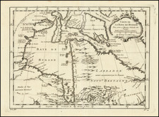
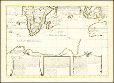
First Separately-Printed Map of the Southern Polar Regions
Rare pair of Antarctic maps, the first to focus so minutely on the South Pole and its environs.
Initially published by Cornelis Wytfliet in 1597, this single-sheet is split into two sections. At top is a map of the Straits of Magellan. Below is a hemispheric projection of Terra Australis, which was entirely a hypothetical construction when this map was issued at the end of the sixteenth century.
The Straits of Magellan, although unlabeled on the upper map, separate Patagonum Regio, or Patagonia, from a large southern continent, Australis Terre Pars. Toponyms within the straits stem from Magellan’s initial sailing of the waterway. Although he left Spain with a fleet, only one of his ships, the Victoria, made it all the way around the world in the first circumnavigation (1519-1522). This ship is included in the waters east of the straits.
The straits were already peopled when Magellan arrived. However, European settlers also tried to make the cold, blustery region their home. After Francis Drake raided the western coast of South America during his own circumnavigation (1577-1580), the Spanish hastened to bolster their presence and defenses in the South Seas. After several ill-fated attempts, Pedro Sarmiento de Gamboa successfully landed roughly 300 settlers. He called the future city Ciudad de Rey Don Felipe after King Philip II of Spain; here it is Philippopolis. However, the settlement did not fare well. When Thomas Cavendish stopped there in 1587, he found ruins and a few survivors; he renamed the place Port Famine.
The hemispheric map features a fascinating depiction of the great southern continent, Terra Australis, an amalgamation of the as-yet-undiscovered Australia and Antarctica. In the Australian section of Terra Australis, the coastline is given an undulating form, hinting at some of the potential half-discoveries of Portuguese and other sailors. This probably represents a reprojection of information from Plancius (e.g. his 1592 world map) whose work was the source for most of Wytfliet's other maps.
States and related maps
This is the second state of the map, dating to 1611. The initial publication date of 1597 has been entirely removed from the title.
This map is the progenitor of the Quad-Bussembachaer map of the same title, issued in 1600. The map was also copied by Metellus in 1598.
Early modern mapping of the South Pole and Terra Australis
Many early modern maps include a vast continent that fills the southernmost latitudes of the world. Some of these constructions are entirely fantastic; others are based on careful compilation work that included the latest expeditions and observations. Geographers would cobble together reports and sightings, often suggesting that singular islands and massive cloud formations indicated the presence of a large continent that counter-balanced the heavy northern continents. This theory of continental balance has ancient origins but continued to be popular into the early modern period.
Some of the most common toponyms used to populate this southern landmass were Beach, Lucach, and Maletur. These would be familiar to anyone who has read Marco Polo’s Travels. These three places were originally regions in Java. The conflation of Java with the southern continent stemmed from an error. Initially, Polo used Arabic usage of Java Major for Java and Java Minor for Sumatra. After a printing mistake made Java Minor seem the largest island in the world in the 1532 edition of Polo’s Travels (Paris and Basel), mapmakers started to accommodate Java Minor, Beach, Lucach, and Maletur in a southern landmass.
Another commonly seen toponym is Psitacorum regio, which refers to an area densely populated with parrots. This place name appeared on Mercator’s 1541 globe and his 1569 world map. It was supposed to have been sighted by Portuguese sailors but was never verified in terms of size or location. This map has both Psitacorum regio and the Polo toponyms.
By the seventeenth century, some mapmakers began to doubt the enormous size of the southern continent, or even its existence at all. In 1639, Henricus Hondius published a map that showed an absence of land at the South Pole. It was surrounded by supposed coast lines, but there was no confident outline of a continent.
Seventy-five years later, in 1714, the theoretical geographer Guillaume Delisle produced a map that showed the routes of navigators that had traveled far south; however, he did not include a southern continent. By the early-eighteenth century, blank space rather than guesswork was preferred by mapmakers, but discussion still raged as to what land lay near the South Pole.
In 1739, Delisle’s son-in-law, Philippe Buache, made this map. He also produced another map that included his conjecture as to what a southern land would look like, based on his theory of watersheds that stemmed from the world’s interlocked mountain ranges and river basins. He researched the southern continents suggested by previous mapmakers, including Ortelius, to create his own construction. The latter map shows a two-part southern continent, separated by a nearly landlocked sea. Buache is clear, however, that this is nothing more than an intellectual exercise.
The understanding of Antarctica shifted from the hypothetical to the practical with the second voyage of James Cook. In the Resolution, he passed the Antarctic Circle three times, the first ship to do so, drastically limiting the area which could be covered by a southern continent. Mainland Antarctica would only by sighted for the first time on January 27, 1820, by members of the Russian expedition under Bellinghausen.
Cornelius de Wytfliet (ca.1550-ca. 1597) was a Flemish cartographer most famous for his Descriptionis Ptolemaicae Augmentum. The work was published in Louvain, Belgium, and had nineteen maps of the Americas.