![Planisphere Physique ou l'on voit du Pole Septentrional ce que l'on connoit de Terres et de Mers Avec les Grandges Chaines de Montagnes . . . [Bay or Sea of the West] By Philippe Buache](https://storage.googleapis.com/raremaps/img/small/98378.jpg)


|
||

|

|
|

|
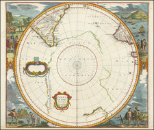
Scarce Buache Map of the World's Watersheds, One of the First Thematic Maps
Fine example of Buache's watershed map of the world, on a North Polar projection. The map shows how mountain chains affect the flow of water into the various oceans. The map was presented to the Acàdemie Royale des Sciences and it is one of the earliest thematic maps. It also shows the mythic Sea of the West.
The continents of the world radiate from a central point, the North Pole. The lands are color coded according to which ocean their watershed empties. The most prominent features are the mountain ranges, which divide the land and the seas. Some are actual mountain ranges, others are placed where Buache hypothesized they must be, for example along the sea floor. To the south, near Cap de la Circoncision, is an unfinished coast line which suggests the presence of another continent. New Zealand, shown on the opposite side of the projection, near the top, is also partially shown and dually labeled as an island and as Terre Antarctique.
The geography of Europe, Asia, and Africa appear familiar, but the outlines of the Pacific region are less so. Australia is incomplete and connected via a land bridge to New Guinea. It extends far to the east, to an island called Terre de St. Esprit. This is a reference to Austrialia de Espiritu Santo, a land contacted in 1606 by Pedro Ferdinand de Quiros. Quiros was an adamant promotor of Pacific colonization and he thought he had landed on a vast continent; in reality, he was on the largest island of the chain that makes up Vanuatu. Quiros is not the only explorer discussed on the map and the others are discussed below.
Sea of the West
Another notable feature is the Sea of the West in the interior of North America. This sea had first appeared on charts published by Johann Baptiste Nolin in ca. 1700, but had quickly disappeared thereafter. Although the great French geographer Guillaume De L'Isle never published a map showing the sea, he had postulated that it could exist, and that it might connect to a Northwest Passage through New France, not through English territory farther north. Nolin had plagiarized the idea from Guillaume, as the latter testified when suing the former for plagiarism. He said, the Sea of the West "was one of my discoveries. But since it is not always appropriate to publish what one knows or what one thinks one knows, I have not had this sea engraved on the works that I made public, not wanting foreigners to profit from this discovery" (as quoted in Pedley, 109).
The Sea of the West began to appear again in the 1752, when Joseph-Nicolas Delisle, Guillaume's brother, and Philippe Buache, his son-in-law, published a map showing the Russian discoveries in the far north Pacific. Buache had reviewed his father-in-law's papers and read of the Sea of the West. He and his uncle included the sea on their map, which was also presented to the Acàdemie, and it spread to other maps thereafter. To learn more of the 1752 map, see here.
The Ring of Explorers and Ice in the Southern Hemisphere
Although watersheds are the main purpose of this map, there are also references to several voyages and explorers around the outer rim of the polar projection. Their tracks form an uneven circle around the southern, or outside, edge of the map. The ring combines the voyages of French, English, Dutch, and Spanish navigators. Together, they show the boundary of the known world.
One track is that of the 1738-9 expedition of Jean-Baptiste Charles Bouvet de Lozier. Bouvet was an employee of the French East India Company who was convinced that, given a chance, he could make discoveries around the South Pole, or near the much vaunted Terra Australis Incognita. In 1739, the Company gave him a chance. Bouvet meticulously searched the South Atlantic, but he had to return to France earlier than expected because his crew became too ill to continue. In the 1750s, he served as the governor of the Mascarene Islands, east of Madagascar. He was France's best known explorer at the time this map was printed.
Bouvet's journals mention icebergs between two and three hundred feet high and half a league to two or three leagues in circumference. Buache made Cap de la Circoncision, sighted by Bouvet, at 54° South, a northern promontory of an unfinished landmass. The icebergs surround the area.
Another voyage marked on the map is that of Edmund Halley, and it too involved icebergs. Halley convinced the British Admiralty to give him a ship, the Paramore, to use as a mobile laboratory for studying magnetic variation. On his second voyage, Halley took the Paramore into the Southern Atlantic. While there, he nearly lost his ship to the soaring icebergs he found there. Halley wrote to Josiah Burchett, Secretary of the Admiralty, on March 30, 1700:
In Lattd: 52 ½ ° and 35° west Longitude from London, we fell in with great Islands of Ice, of soe Incredible a hight and Magnitude, that I scarce dare write my thoughts of it, at first we took it for land with chaulky cliffs, and the topp all covered with snow, but we soon found our mistake by standing in with it, and that it was nothing but Ice, though it could not be less then 200 foot high, and one Island at least 5 mile in front, we could not get ground in 140 fadtham. Yet I conceive it was aground, Ice being very little lighter then water and not above an Eight part above the Surface when it swims…
Halley, awed by the size of the icebergs, hypothesized that they must be land, not floating, as ice typically concealed more beneath the surface than above and Halley could not imagine a floating entity so large.
Farther west along the ring are more icebergs, those sighted by Drake on his privateering circumnavigation in 1577-80. Finally, there are the icebergs recorded by the buccaneers Bartholomew Sharpe and John Davis on their piratical wanderings in 1687. All four sets of icebergs are proof to Buache that the European adventurers were nearing a southern continent.
The other explorers who are included in the ring, although they didn't see icebergs, are Ferdinand Magellan, the world's first circumnavigator, and Abel Tasman, who made first European contact with New Zealand in the 1640s. In the mid-Pacific, Le Maire's voyage of 1616 makes up part of the ring. Jacob Le Maire, along with Willem Schouten, circumnavigated via Cape Horn in 1615-1617, the first to sail round South America instead of through the Straits of Magellan. Finally, the track of the St. Louis, dated 1708, crosses the South Atlantic. It was a French merchant enterprise and was the first ship to cross from Cape Horn to the Cape of Good Hope.
Thematic maps
Buache was an academic geographer who researched his material thoroughly, relying on the most up-to-date information from the voyages of discovery. As previously stated, he was Guillaume Delisle's son-in-law and served as premier gèographe du roi, gèographe adjoint to the Acàdemie. He was the first geographer to survey a river basin and suggested that the basin had topographical unity in a paper given to the Acàdemie in 1752, as mentioned in the title of this map. Although the word watershed did not come into use until the early nineteenth century, based on the German wasserscheide, Buache pioneered the important concept.
This map was one of the earliest thematic maps. Scholars disagree as to which map is the first thematic map, and some say examples come from as early as the Middle Ages. In telling the story of thematic mapping, most histories usually cite Halley's maps on the trade winds and magnetic variation. Scholars also like to focus on John Snow's cholera map. There are other examples, however, including this one, which are less integrated into the history of thematic maps. With Buache's prominence in the world of cartography and science, this map would have been an influential example of thematic mapping. By the end of the eighteenth century, the genre was growing fast and maps were being used to illustrate many spatial phenomena.
Mary Sponberg Pedley, The Commerce of Cartography: Making and Marketing Maps in Eighteenth-Century France and England (Chicago: University of Chicago Press, 2005).
Josef Konvitz, Cartography in France, 1660-1848: Science, Engineering, and Statecraft (Chicago: University of Chicago Press, 1987).
Norman J. W. Thrower, ed. The Three Voyages of Edmond Halley in the Paramore 1698-1701 (London: Hakluyt Society, 1981), document 84.
Philippe Buache (1700-1773) was one of the most famous French geographers of the eighteenth century. Buache was married to the daughter of the eminent Guillaume Delisle and worked with his father-in-law, carrying on the business after Guillaume died. Buache gained the title geographe du roi in 1729 and was elected to the Academie des Sciences in the same year. Buache was a pioneering theoretical geographer, especially as regards contour lines and watersheds. He is best known for his works such as Considérations géographiques et physiques sur les découvertes nouvelles dans la grande mer (Paris, 1754).
![[Alaska / Mount St. Elias and Mt. Fairweather to Cape Decision, Stika, Juneau and Prince Frederick Sound] A Chart Shewing Part of the Coast of N.W. America, with the Tracks . . .](https://storage.googleapis.com/raremaps/img/small/102066.jpg)