|
||

|

|
|

|
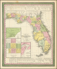
Fascinating cadastral map of the Miami-Fort Lauderdale metropolitan area, focusing on lot divisions in the interior of the Broward and Dade Counties.
The map was prepared by Karl Squires, who was an active Miami-based mapmaker in the 1920s and '30s. The map extends about as far west as the intersection between the Miami Canal and the Dade-Broward County border. Thus the western part of the map is probably the East Coast Buffer Water Preserve Area.
A note in pencil manuscript says "$1000.00 Per Acre $1800 Rents", elsewhere there is a note "$1250 per acres". Presumably, these notes are related to sales pitches to buy undeveloped or agricultural land in the interior.
An important map illustrating the grid on which suburban Miami would grow over the following century.
Rarity
This kind of real estate map was produced in a relatively small volume and its separate and ephemeral nature means that few remain today.
No copies in OCLC. Not at the Touchton Map Library.
![[ Death of a Florida Indian Chief ] Ceremoniae in Regis & Sacerdotum funere observatae. XL.](https://storage.googleapis.com/raremaps/img/small/97768.jpg)